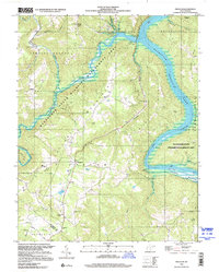
1998 Map of Pipestem
USGS Topo · Published 2000About this map
Bluestone Lake dominates the northern reaches of this map, where the waters of the New River and Little Bluestone River meet within a landscape of protected conservation areas. This terrain is defined by the high ridges of Tallery Mountain and Bluestone Mountain, framing the settlement at Pipestem and the surrounding recreation areas. The map details a rural geography of small crossroads such as True and Ellison, where community life centers on landmarks like James Chapel and Pipestem Ch. To the south, the Summers and Mercer County line cuts through high ground near Lerona, while the broad expanse of Crumps Bottom along the river offers a distinct contrast to the surrounding knobs. This late-century survey illustrates the balance between the established public lands of Bluestone State Park and the isolated farmsteads and family cemeteries scattered across the hollows.
Find a feature on this map
46 named features on this map. Tap any name to fly to it.
Don’t see what you’re looking for? This feature index may not catch every label — zoom into the map to look around manually.
Map Details
Editions of this 1998 Pipestem Map
This is the sole edition of this map. No revisions or reprints were ever made.
Other maps of this area

1887 · Pocahontas
USGS Topo · 1:125,000

1887 · Hinton
USGS Topo · 1:125,000

1890 · Dublin
USGS Topo · 1:125,000

1891 · Pocahontas
USGS Topo · 1:125,000

1891 · Dublin
USGS Topo · 1:125,000

1891 · Raleigh
USGS Topo · 1:125,000

1892 · Hinton
USGS Topo · 1:125,000

1894 · Pocahontas
USGS Topo · 1:125,000

1895 · Pocahontas
USGS Topo · 1:125,000

1897 · Raleigh
USGS Topo · 1:125,000