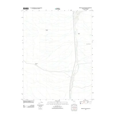
2011 Map of Pirouette Mountain
USGS Topo · Published 2011About this map
Pirouette Mountain stands as a prominent landmark in this desert landscape of Churchill County, where drainage patterns define the arid terrain. The map traces the natural watercourses of the Dixie Valley Wash and Elevenmile Wash, which collect runoff from the surrounding elevations and deep-cut features such as Slaughter Canyon and Elevenmile Canyon. This 2011 survey by the U.S. Geological Survey details the remote environment where seasonal water sources and topographic shifts dominate. To the north, Cain Spring and the drainage of Red Top Gulch provide specific points of reference for those navigating the eastern slopes. A single primary artery, Dixie Valley Rd, provides the essential modern link through this expansive basin, following the natural floor of the valley.
Find a feature on this map
8 named features on this map. Tap any name to fly to it.
Don’t see what you’re looking for? This feature index may not catch every label — zoom into the map to look around manually.
Map Details
Editions of this 2011 Pirouette Mountain Map
This is the sole edition of this map. No revisions or reprints were ever made.
Other maps of this area

1908 · Carson Sink
USGS Topo · 1:250,000

1910 · Carson Sink
USGS Topo · 1:250,000

1957 · Reno
USGS Topo · 1:250,000

1959 · Reno
USGS Topo · 1:250,000

1960 · Reno
USGS Topo · 1:250,000

1969 · Table Mtn
USGS Topo · 1:24,000

1972 · Pirouette Mtn
USGS Topo · 1:24,000
1972 · Job Peak
USGS Topo · 1:24,000
1972 · Wonder Mountain
USGS Topo · 1:24,000
1972 · Dixie Valley SE
USGS Topo · 1:24,000