1950 Map of Pitas Point
USGS Topo · Published 1987About this map
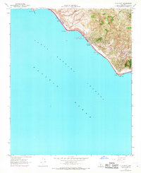
The coastal boundary between Santa Barbara and Ventura counties is defined by Rincon Cr, where the steep foothills of Rincon Mtn drop sharply to the Pacific Ocean. This narrow corridor of land supports a dense concentration of infrastructure, including the Southern Pacific railroad and the Pacific Coast Highway, which hug the shoreline through the small settlements of Punta and Sea Cliff. The presence of numerous Oil Wells, an Oil Sump, and a network of pipelines indicates the significant petroleum activity taking place on the hillsides and near the coast at mid-century.
Find a feature on this map
25 named features on this map. Tap any name to fly to it.
Don’t see what you’re looking for? This feature index may not catch every label — zoom into the map to look around manually.
Map Details
Editions of this 1950 Pitas Point Map
3 editions found

Historical Maps of Carpinteria Through Time
237 maps found

1900 Triunfo Pass
Ventura County, CA

1903 Mt. Pinos
Ventura County, CA

1904 Hueneme
Ventura County, CA

1904 Ventura
Ventura County, CA

1921 Triunfo Pass
Ventura County, CA

1925 Chatsworth
Ventura County, CA

1927 Chatsworth
Ventura County, CA

1929 Chatsworth
Ventura County, CA

1931 Santa Felicia Canyon
Ventura County, CA

1933 Chatsworth
Ventura County, CA

1935 Santa Felicia Canyon
Ventura County, CA

1938 Black Mountain
Ventura County, CA

1940 Chatsworth
Ventura County, CA

1941 Ventura
Ventura County, CA

1942 Hueneme
Ventura County, CA

1942 Wheeler Springs
Ventura County, CA

1943 Apache Canyon
Ventura County, CA

1943 Cuddy Valley
Ventura County, CA

1943 Cuyama Peak
Ventura County, CA

1943 Devils Heart Peak
Ventura County, CA

1943 Hueneme
Ventura County, CA

1943 Lion Canyon
Ventura County, CA

1943 Lockwood Valley
Ventura County, CA

1943 Rancho Nuevo Creek
Ventura County, CA

1943 Reyes Peak
Ventura County, CA

1943 San Guillermo
Ventura County, CA

1943 San Nicolas Island
Ventura County, CA

1943 Sawmill Mountain
Ventura County, CA

1943 Topatopa Mountains
Ventura County, CA

1943 Triunfo Pass
Ventura County, CA

1943 Wheeler Springs
Ventura County, CA

1944 Cobblestone Mountain
Ventura County, CA

1944 Cuddy Valley
Ventura County, CA

1944 Cuyama Peak
Ventura County, CA

1944 Devils Heart Peak
Ventura County, CA

1944 Lion Canyon
Ventura County, CA

1944 Lockwood Valley
Ventura County, CA

1944 San Guillermo
Ventura County, CA

1944 Sawmill Mountain
Ventura County, CA

1944 Topatopa Mountains
Ventura County, CA

1944 Wheeler Springs
Ventura County, CA

1945 Apache Canyon
Ventura County, CA

1945 Reyes Peak
Ventura County, CA

1949 Point Mugu
Ventura County, CA

1949 Triunfo Pass
Ventura County, CA

1950 Newbury Park
Ventura County, CA

1950 Pitas Point
Ventura County, CA

1950 Point Mugu
Ventura County, CA

1950 Triunfo Pass
Ventura County, CA

1951 Newbury Park
Ventura County, CA

1951 Pitas Point
Ventura County, CA

1951 Santa Paula Peak
Ventura County, CA

1951 Simi Valley East
Ventura County, CA

1951 Simi Valley West
Ventura County, CA

1951 Ventura
Ventura County, CA

1952 Matilija
Ventura County, CA

1952 White Ledge Peak
Ventura County, CA

1956 San Nicolas Island
Ventura County, CA

1958 Alamo Mountain
Ventura County, CA

1958 Cobblestone Mtn
Ventura County, CA

1976 Devils Heart Peak
Ventura County, CA

1977 Cuyama Peak
Ventura County, CA

1991 Alamo Mountain
Ventura County, CA

1991 Apache Canyon
Ventura County, CA

1991 Cobblestone Mtn
Ventura County, CA

1991 Cuddy Valley
Ventura County, CA

1991 Cuyama Peak
Ventura County, CA

1991 Devils Heart Peak
Ventura County, CA

1991 Lion Canyon
Ventura County, CA

1991 Lockwood Valley
Ventura County, CA

1991 Rancho Nuevo Creek
Ventura County, CA

1991 Reyes Peak
Ventura County, CA

1991 San Guillermo Mtn
Ventura County, CA

1991 Sawmill Mountain
Ventura County, CA

1991 Topatopa Mountains
Ventura County, CA

1991 Triunfo Pass
Ventura County, CA

1991 Wheeler Springs
Ventura County, CA

1993 San Nicolas Island
Ventura County, CA

1994 Triunfo Pass
Ventura County, CA

1995 Alamo Mountain
Ventura County, CA

1995 Apache Canyon
Ventura County, CA

1995 Cobblestone Mountain
Ventura County, CA

1995 Cuddy Valley
Ventura County, CA

1995 Cuyama Peak
Ventura County, CA

1995 Devils Heart Peak
Ventura County, CA

1995 Lion Canyon
Ventura County, CA

1995 Lockwood Valley
Ventura County, CA

1995 Matilija
Ventura County, CA

1995 Rancho Nuevo Creek
Ventura County, CA

1995 Reyes Peak
Ventura County, CA

1995 San Guillermo Mountain
Ventura County, CA

1995 Santa Paula Peak
Ventura County, CA

1995 Sawmill Mountain
Ventura County, CA

1995 Topatopa Mountains
Ventura County, CA

1995 Wheeler Springs
Ventura County, CA

1995 White Ledge Peak
Ventura County, CA

2012 Alamo Mountain
Ventura County, CA

2012 Anacapa Island OE E
Ventura County, CA

2012 Anacapa Island OE SE
Ventura County, CA

2012 Anacapa Island OE S
Ventura County, CA

2012 Anacapa Island
Ventura County, CA

2012 Apache Canyon
Ventura County, CA

2012 Cobblestone Mountain
Ventura County, CA

2012 Cuddy Valley
Ventura County, CA

2012 Cuyama Peak
Ventura County, CA

2012 Devils Heart Peak
Ventura County, CA

2012 Lion Canyon
Ventura County, CA

2012 Lockwood Valley
Ventura County, CA

2012 Matilija
Ventura County, CA

2012 Newbury Park
Ventura County, CA

2012 Oxnard OE W
Ventura County, CA

2012 Pitas Point
Ventura County, CA

2012 Point Dume OE S
Ventura County, CA

2012 Point Mugu OE W
Ventura County, CA

2012 Point Mugu
Ventura County, CA

2012 Rancho Nuevo Creek
Ventura County, CA

2012 Reyes Peak
Ventura County, CA

2012 San Guillermo Mountain
Ventura County, CA

2012 San Nicolas Island OE N
Ventura County, CA

2012 San Nicolas Island OE NW
Ventura County, CA

2012 San Nicolas Island OE SW
Ventura County, CA

2012 San Nicolas Island
Ventura County, CA

2012 Santa Paula Peak
Ventura County, CA

2012 Sawmill Mountain
Ventura County, CA

2012 Simi Valley East
Ventura County, CA

2012 Simi Valley West
Ventura County, CA

2012 Topatopa Mountains
Ventura County, CA

2012 Triunfo Pass
Ventura County, CA

2012 Ventura
Ventura County, CA

2012 Wheeler Springs
Ventura County, CA

2012 White Ledge Peak
Ventura County, CA

2015 Alamo Mountain
Ventura County, CA

2015 Anacapa Island OE E
Ventura County, CA

2015 Anacapa Island OE SE
Ventura County, CA

2015 Anacapa Island OE S
Ventura County, CA

2015 Anacapa Island
Ventura County, CA

2015 Apache Canyon
Ventura County, CA

2015 Cobblestone Mountain
Ventura County, CA

2015 Cuddy Valley
Ventura County, CA

2015 Cuyama Peak
Ventura County, CA

2015 Devils Heart Peak
Ventura County, CA

2015 Lion Canyon
Ventura County, CA

2015 Lockwood Valley
Ventura County, CA

2015 Matilija
Ventura County, CA

2015 Newbury Park
Ventura County, CA

2015 Oxnard OE W
Ventura County, CA

2015 Pitas Point
Ventura County, CA

2015 Point Dume OE S
Ventura County, CA

2015 Point Mugu OE W
Ventura County, CA

2015 Point Mugu
Ventura County, CA

2015 Rancho Nuevo Creek
Ventura County, CA

2015 Reyes Peak
Ventura County, CA

2015 San Guillermo Mountain
Ventura County, CA

2015 San Nicolas Island OE N
Ventura County, CA

2015 San Nicolas Island OE NW
Ventura County, CA

2015 San Nicolas Island OE SW
Ventura County, CA

2015 San Nicolas Island
Ventura County, CA

2015 Santa Paula Peak
Ventura County, CA

2015 Sawmill Mountain
Ventura County, CA

2015 Simi Valley East
Ventura County, CA

2015 Simi Valley West
Ventura County, CA

2015 Topatopa Mountains
Ventura County, CA

2015 Triunfo Pass
Ventura County, CA

2015 Ventura
Ventura County, CA

2015 Wheeler Springs
Ventura County, CA

2015 White Ledge Peak
Ventura County, CA

2018 Alamo Mountain
Ventura County, CA

2018 Anacapa Island OE E
Ventura County, CA

2018 Anacapa Island OE SE
Ventura County, CA

2018 Anacapa Island OE S
Ventura County, CA

2018 Anacapa Island
Ventura County, CA

2018 Apache Canyon
Ventura County, CA

2018 Cobblestone Mountain
Ventura County, CA

2018 Cuddy Valley
Ventura County, CA

2018 Cuyama Peak
Ventura County, CA

2018 Devils Heart Peak
Ventura County, CA

2018 Lion Canyon
Ventura County, CA

2018 Lockwood Valley
Ventura County, CA

2018 Matilija
Ventura County, CA

2018 Newbury Park
Ventura County, CA

2018 Oxnard OE W
Ventura County, CA

2018 Pitas Point
Ventura County, CA

2018 Point Dume OE S
Ventura County, CA

2018 Point Mugu OE W
Ventura County, CA

2018 Point Mugu
Ventura County, CA

2018 Rancho Nuevo Creek
Ventura County, CA

2018 Reyes Peak
Ventura County, CA

2018 San Guillermo Mountain
Ventura County, CA

2018 San Nicolas Island OE N
Ventura County, CA

2018 San Nicolas Island OE NW
Ventura County, CA

2018 San Nicolas Island OE SW
Ventura County, CA

2018 San Nicolas Island
Ventura County, CA

2018 Santa Paula Peak
Ventura County, CA

2018 Sawmill Mountain
Ventura County, CA

2018 Simi Valley East
Ventura County, CA

2018 Simi Valley West
Ventura County, CA

2018 Topatopa Mountains
Ventura County, CA

2018 Triunfo Pass
Ventura County, CA

2018 Ventura
Ventura County, CA

2018 Wheeler Springs
Ventura County, CA

2018 White Ledge Peak
Ventura County, CA

2021 Alamo Mountain
Ventura County, CA

2021 Anacapa Island OE SE
Ventura County, CA

2021 Anacapa Island OE S
Ventura County, CA

2021 Anacapa Island
Ventura County, CA

2021 Cuyama Peak
Ventura County, CA

2021 Devils Heart Peak
Ventura County, CA

2021 Lion Canyon
Ventura County, CA

2021 Lockwood Valley
Ventura County, CA

2021 Newbury Park
Ventura County, CA

2021 Point Mugu OE W
Ventura County, CA

2021 Rancho Nuevo Creek
Ventura County, CA

2021 Reyes Peak
Ventura County, CA

2021 San Guillermo Mountain
Ventura County, CA

2021 San Nicolas Island OE N
Ventura County, CA

2021 San Nicolas Island OE NW
Ventura County, CA

2021 San Nicolas Island OE SW
Ventura County, CA

2021 San Nicolas Island
Ventura County, CA

2021 Santa Paula Peak
Ventura County, CA

2021 Wheeler Springs
Ventura County, CA

2022 Anacapa Island OE E
Ventura County, CA

2022 Apache Canyon
Ventura County, CA

2022 Cobblestone Mountain
Ventura County, CA

2022 Cuddy Valley
Ventura County, CA

2022 Matilija
Ventura County, CA

2022 Oxnard OE W
Ventura County, CA

2022 Pitas Point
Ventura County, CA

2022 Point Dume OE S
Ventura County, CA

2022 Point Mugu
Ventura County, CA

2022 Sawmill Mountain
Ventura County, CA

2022 Simi Valley East
Ventura County, CA

2022 Simi Valley West
Ventura County, CA

2022 Topatopa Mountains
Ventura County, CA

2022 Triunfo Pass
Ventura County, CA

2022 Ventura
Ventura County, CA

2022 White Ledge Peak
Ventura County, CA

2023 Devils Heart Peak
Ventura County, CA