
1947 Map of Pittsburg
USGS Topo · Published 1978About this map
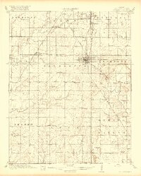
Pittsburg and its surrounding coalfields dominate this 1940s landscape, where industrial extraction and rural education coexist along the Kansas-Missouri border. The region is heavily marked by Strip Mines, particularly around Mindenmines and Frontenac, creating a distinct topography of excavated pits and tailing mounds. This industrial footprint is interlaced with a dense network of early transportation, including the Kansas City Southern, Missouri Pacific, and St Louis San Francisco railroads that hauled minerals from the district.
Find a feature on this map
70 named features on this map. Tap any name to fly to it.
Don’t see what you’re looking for? This feature index may not catch every label — zoom into the map to look around manually.
Map Details
Editions of this 1947 Pittsburg Map
This is the sole edition of this map. No revisions or reprints were ever made.
Other maps of this area

1884 · Fort Scott
USGS Topo · 1:125,000

1886 · Nevada
USGS Topo · 1:125,000

1886 · Joplin
USGS Topo · 1:125,000

1886 · Fort Scott
USGS Topo · 1:125,000

1886 · Carthage
USGS Topo · 1:125,000

1893 · Fort Scott
USGS Topo · 1:125,000

1894 · Nevada
USGS Topo · 1:125,000

1894 · Joplin
USGS Topo · 1:125,000

1894 · Carthage
USGS Topo · 1:125,000
1918 · Columbus
USGS Topo · 1:62,500