
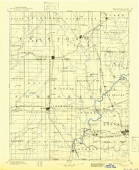
1894 Map of Joplin
USGS Topo · Published 1894About this map
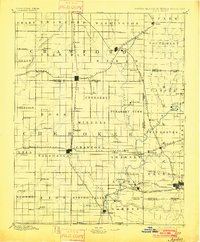
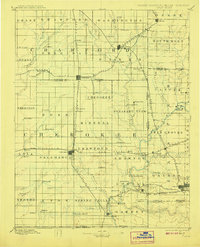
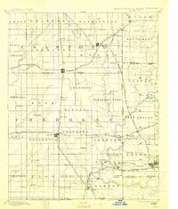
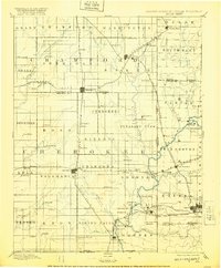
The Kansas Missouri Boundary Line bisects this late nineteenth-century landscape, capturing a period of intense rail expansion and coal-country growth. In the northern sections, Pittsburg and Frontenac emerge as industrial hubs along the Kansas City Fort Scott and Memphis Railroad, while to the south, Joplin anchors the Missouri side of the border. This survey depicts the region before the formalization of Oklahoma, labeling the southern edge as the Kansas Indian Territory Boundary Line. Numerous smaller settlements and rail stops like Scammon, Weir, and Stippville are documented along the complex network of tracks, reflecting the dense mining and agricultural activity of the era. Natural features such as Shoal Creek and Lightning Creek wind through the township grids, providing the water sources that supported the early development of Baxter Springs and Columbus.
Find a feature on this map
103 named features on this map. Tap any name to fly to it.
Don’t see what you’re looking for? This feature index may not catch every label — zoom into the map to look around manually.
Map Details
Editions of this 1894 Joplin Map
6 editions found
Other maps of this area

1884 · Fort Scott
USGS Topo · 1:125,000

1886 · Nevada
USGS Topo · 1:125,000

1886 · Joplin
USGS Topo · 1:125,000

1886 · Iola
USGS Topo · 1:125,000

1886 · Fort Scott
USGS Topo · 1:125,000

1886 · Carthage
USGS Topo · 1:125,000

1886 · Parsons
USGS Topo · 1:125,000

1893 · Fort Scott
USGS Topo · 1:125,000
1893 · Iola
USGS Topo · 1:125,000

1893 · Parsons
USGS Topo · 1:125,000