1886 Map of Joplin
USGS Topo · Published 1886About this map
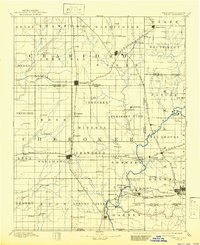
Spring River and its numerous tributaries, including Blackberry Creek and Shoal Creek, dominate this late-nineteenth-century landscape across the Missouri-Kansas border. The region is characterized by a dense network of early settlements and emerging industrial hubs connected by the Kansas City Fort Scott and Gulf Railroad and the St. Louis and San Francisco Railroad. Significant local centers like Columbus, Pittsburg, and Carl Junction appear alongside smaller, vanished hamlets such as Georgia City and Litchfield. The map's detailed township and range divisions, including the Mineral and Pleasant View districts, reflect a period of rapid agricultural and industrial expansion. Genealogists can trace family connections to rural communities like Star Valley, Minden, and Waco, providing a clear view of the area's social geography before the turn of the century.
Find a feature on this map
91 named features on this map. Tap any name to fly to it.
Don’t see what you’re looking for? This feature index may not catch every label — zoom into the map to look around manually.
Map Details
Editions of this 1886 Joplin Map
This is the sole edition of this map. No revisions or reprints were ever made.
Historical Maps of Joplin Through Time
9 maps found