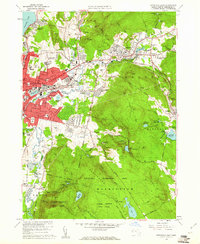
1959 Map of Pittsfield East
USGS Topo · Published 1961About this map
Pittsfield serves as the urban anchor for this Berkshire county landscape, where the industrialized Housatonic River valley meets the rising topography of the surrounding hill towns. The map reveals a mid-century period of suburban expansion with clusters like Lakeview Terrace and Lakewood filling in the spaces between the city and Lanesboro. Public utilities and water management dominate the south and east, represented by the expansive Pittsfield Washington Watershed Area and numerous high-elevation water bodies including Ashley Lake and Farnham Reservoir.
Find a feature on this map
73 named features on this map. Tap any name to fly to it.
Don’t see what you’re looking for? This feature index may not catch every label — zoom into the map to look around manually.
Map Details
Editions of this 1959 Pittsfield East Map
2 editions found
Other maps of this area

1886 · Greylock
USGS Topo · 1:62,500

1886 · Becket
USGS Topo · 1:62,500

1888 · Becket
USGS Topo · 1:62,500

1888 · Berlin
USGS Topo · 1:62,500

1888 · Pittsfield
USGS Topo · 1:62,500

1890 · Pittsfield
USGS Topo · 1:62,500

1890 · Berlin
USGS Topo · 1:62,500

1891 · Greylock
USGS Topo · 1:62,500

1893 · Becket
USGS Topo · 1:62,500

1893 · Greylock
USGS Topo · 1:62,500