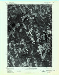
1975 Map of Pittsfield NE
USGS Topo · Published 1980About this map
Ripley and the rural crossroads of Somerset County define this mid-1970s landscape, captured in a detailed orthophotograph. The settlement pattern is characterized by historic "corners" that served as local hubs, including Pleasant Vale Corner, Nutter Corner, and Sanborn Corner. These small junctions reflect the agricultural and timber-based economy of the region, where cleared fields stand in sharp contrast to the dense Maine woodlands. Waterways dictate much of the local geography, with the East Branch Sebasticook River and Mulligan Stream winding through the terrain toward the southern reaches of Sebasticook Lake. The map also captures the village of Corinna at the edge of the quadrangle, alongside Indian Pond, providing a rare photographic perspective of these communities during a period of relative stability in rural Maine.
Find a feature on this map
9 named features on this map. Tap any name to fly to it.
Don’t see what you’re looking for? This feature index may not catch every label — zoom into the map to look around manually.
Map Details
Editions of this 1975 Pittsfield NE Map
This is the sole edition of this map. No revisions or reprints were ever made.
Other maps of this area

1930 · Pittsfield
USGS Topo · 1:48,000

1931 · Stetson
USGS Topo · 1:48,000

1932 · Dover-Foxcroft
USGS Topo · 1:48,000

1932 · Pittsfield
USGS Topo · 1:62,500

1933 · Pittsfield
USGS Topo · 1:62,500

1933 · Guilford
USGS Topo · 1:62,500

1935 · Dover-Foxcroft
USGS Topo · 1:62,500

1935 · Stetson
USGS Topo · 1:62,500

1937 · Guilford
USGS Topo · 1:62,500

1948 · Bangor
USGS Topo · 1:250,000