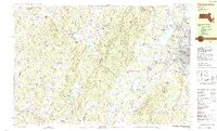
1988 Map of Pittsfield West
USGS Topo · Published 1988About this map
The Taconic Range forms a prominent natural barrier along the border between New York and Massachusetts, separating the small valley hamlets of Columbia County from the urban center of Pittsfield. In the late 1980s, this landscape preserved a distinct contrast between the wooded slopes of the Pittsfield State Forest and the growing municipal infrastructure of Berkshire County. Near the state line, the Taconic Skyline Trail traverses peaks like Perry Peak and Mt Lebanon, overlooking the communal history of Shaker Village.
Find a feature on this map
77 named features on this map. Tap any name to fly to it.
Don’t see what you’re looking for? This feature index may not catch every label — zoom into the map to look around manually.
Map Details
Editions of this 1988 Pittsfield West Map
2 editions found
Other maps of this area

1886 · Greylock
USGS Topo · 1:62,500

1886 · Becket
USGS Topo · 1:62,500

1888 · Becket
USGS Topo · 1:62,500

1888 · Berlin
USGS Topo · 1:62,500

1888 · Pittsfield
USGS Topo · 1:62,500

1890 · Pittsfield
USGS Topo · 1:62,500

1890 · Berlin
USGS Topo · 1:62,500

1891 · Greylock
USGS Topo · 1:62,500

1893 · Troy
USGS Topo · 1:62,500

1893 · Becket
USGS Topo · 1:62,500