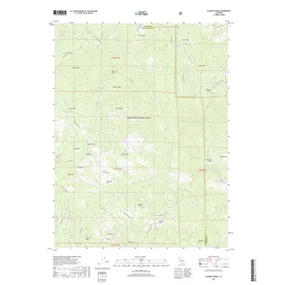
2018 Map of Plaskett Ridge
USGS Topo · Published 2018About this map
Mendocino National Forest defines this high-elevation landscape, where the Black Butte River and its numerous tributaries like Salmon Cr and Baldy Cr carve through a complex series of ridges. This 2018 survey reveals a network of remote flats and peaks that have long served as landmarks for forestry and local navigation. Small clearings such as Coffee Mill Flat, Surveyors Flat, and the curiously named Buzzard Roost suggest historical land use patterns in an area dominated by timber and watershed management. The terrain is marked by distinctive geological features like Blue Rocks, Haydon Rock, and Coyote Rock, which provide fixed points across the drainage basins of the Mississippi Cr and Buckhorn Cr. High points including Little Baldy and Umbrella Butte rise above the basin, connected by narrow forest roads and jeep trails such as the Logan Basin-Jeep track.
Find a feature on this map
73 named features on this map. Tap any name to fly to it.
Don’t see what you’re looking for? This feature index may not catch every label — zoom into the map to look around manually.
Map Details
Editions of this 2018 Plaskett Ridge Map
This is the sole edition of this map. No revisions or reprints were ever made.
Other maps of this area

1926 · Covelo
USGS Topo · 1:62,500

1929 · Eden Valley
USGS Topo · 1:62,500

1952 · Hull Mountain
USGS Topo · 1:62,500

1952 · Eden Valley
USGS Topo · 1:62,500

1952 · Covelo
USGS Topo · 1:62,500

1952 · Anthony Peak
USGS Topo · 1:62,500

1957 · Ukiah
USGS Topo · 1:250,000

1960 · Ukiah
USGS Topo · 1:250,000
1966 · Sanhedrin Mtn
USGS Topo · 1:24,000

1967 · Plaskett Ridge
USGS Topo · 1:24,000