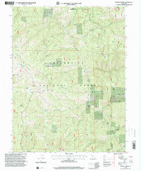
1996 Map of Plaskett Ridge
USGS Topo · Published 2001About this map
Mendocino National Forest defines this high-elevation landscape, where a network of ridgelines like Etsel Ridge and Plaskett Ridge separate deep drainage basins. The map illustrates a history of mountain habitation and forestry management in the mid-1990s, recording numerous named sites such as O'Neil Place, Carpenter Place, and Keller Place. These locations, alongside Post Camp and the Grizzly Flat A S, suggest a legacy of seasonal grazing, fire lookout stations, or homesteading in the Mendocino wilderness.
Find a feature on this map
56 named features on this map. Tap any name to fly to it.
Don’t see what you’re looking for? This feature index may not catch every label — zoom into the map to look around manually.
Map Details
Editions of this 1996 Plaskett Ridge Map
This is the sole edition of this map. No revisions or reprints were ever made.
Other maps of this area

1926 · Covelo
USGS Topo · 1:62,500

1929 · Eden Valley
USGS Topo · 1:62,500

1952 · Hull Mountain
USGS Topo · 1:62,500

1952 · Eden Valley
USGS Topo · 1:62,500

1952 · Covelo
USGS Topo · 1:62,500

1952 · Anthony Peak
USGS Topo · 1:62,500

1957 · Ukiah
USGS Topo · 1:250,000

1960 · Ukiah
USGS Topo · 1:250,000
1966 · Sanhedrin Mtn
USGS Topo · 1:24,000

1967 · Plaskett Ridge
USGS Topo · 1:24,000