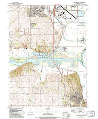
1994 Map of Plattsmouth
USGS Topo · Published 1994About this map
The confluence of the Platte River and Missouri River anchors this landscape, where the shifting boundaries of Sarpy and Cass counties meet. At the northern edge, Offutt Air Force Base and its associated Military Reservation represent the modern strategic importance of the region, while the city of Plattsmouth serves as the southern center of gravity with its prominent Courthouse and Central School. The map illustrates the region's industrial and agricultural balance, featuring numerous quarries and a sand and gravel pit alongside the sprawling Schilling State Wildlife Area.
Find a feature on this map
42 named features on this map. Tap any name to fly to it.
Don’t see what you’re looking for? This feature index may not catch every label — zoom into the map to look around manually.
Map Details
Editions of this 1994 Plattsmouth Map
This is the sole edition of this map. No revisions or reprints were ever made.
Other maps of this area

1893 · Fremont
USGS Topo · 1:125,000

1896 · Fremont
USGS Topo · 1:125,000

1903 · Weeping Water
USGS Topo · 1:125,000

1929 · Weeping Water
USGS Topo · 1:125,000

1935 · Nehawka
USGS Topo · 1:48,000

1940 · Nehawka
USGS Topo · 1:62,500

1954 · Omaha
USGS Topo · 1:250,000

1955 · Fremont
USGS Topo · 1:250,000

1955 · Nebraska City
USGS Topo · 1:250,000

1955 · Lincoln
USGS Topo · 1:250,000