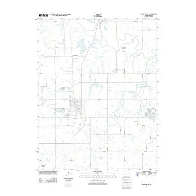
2012 Map of Pleasanton
USGS Topo · Published 2012About this map
The Marais des Cygnes River winds through the northern reaches of this Linn County landscape, passing the small settlement of Trading Post. To the south, the city of Pleasanton serves as a primary hub of development, centered around Main St and Cedar St. The surrounding countryside is defined by a dense network of rural roads such as Snider Rd and Wattles Rd, which connect numerous family and community landmarks. Genealogists will find a high concentration of burial sites throughout the township, including the Lamb Mills Cem, Eureka Cem, and Green Valley Cem. Educational history is preserved at the Green Valley School, while local infrastructure is represented by the Pleasanton City Lake and specialized aviation facilities like Yeamans Fox Nest Airport. The drainage patterns of Big Sugar Cr and Mine Cr further illustrate the area's natural topography.
Find a feature on this map
82 named features on this map. Tap any name to fly to it.
Don’t see what you’re looking for? This feature index may not catch every label — zoom into the map to look around manually.
Map Details
Editions of this 2012 Pleasanton Map
This is the sole edition of this map. No revisions or reprints were ever made.
Other maps of this area

1887 · Mound City
USGS Topo · 1:125,000

1893 · Mound City
USGS Topo · 1:125,000

1938 · Worland
USGS Topo · 1:24,000

1940 · Worland
USGS Topo · 1:24,000

1940 · Hume
USGS Topo · 1:24,000

1942 · Hume
USGS Topo · 1:24,000

1947 · Lawrence
USGS Topo · 1:250,000

1950 · Lawrence
USGS Topo · 1:250,000

1956 · Lawrence
USGS Topo · 1:250,000
1957 · Boicourt
USGS Topo · 1:24,000