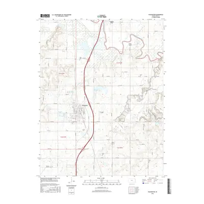
2016 Map of Pleasanton
USGS Topo · Published 2016About this map
The Marais des Cygnes River winds across the northeast corner of this Linn County landscape, while Big Sugar Cr and Mine Creek define the drainage of the surrounding prairie. Pleasanton serves as the primary hub, with its grid of streets anchored by Pleasanton Cem and the nearby Pleasanton Lake. To the north lies the historic settlement of Trading Post, situated near the river and the modern highway corridor.
Find a feature on this map
88 named features on this map. Tap any name to fly to it.
Don’t see what you’re looking for? This feature index may not catch every label — zoom into the map to look around manually.
Map Details
Editions of this 2016 Pleasanton Map
This is the sole edition of this map. No revisions or reprints were ever made.
Other maps of this area

1887 · Mound City
USGS Topo · 1:125,000

1893 · Mound City
USGS Topo · 1:125,000

1938 · Worland
USGS Topo · 1:24,000

1940 · Worland
USGS Topo · 1:24,000

1940 · Hume
USGS Topo · 1:24,000

1942 · Hume
USGS Topo · 1:24,000

1947 · Lawrence
USGS Topo · 1:250,000

1950 · Lawrence
USGS Topo · 1:250,000

1956 · Lawrence
USGS Topo · 1:250,000
1957 · Boicourt
USGS Topo · 1:24,000