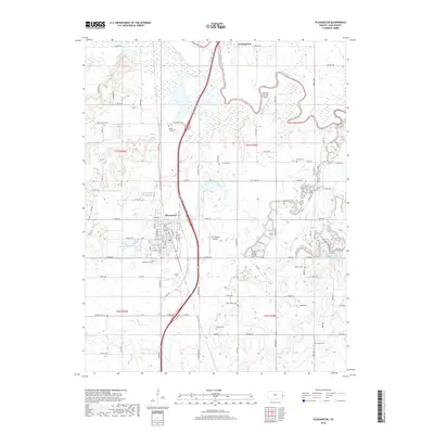
2018 Map of Pleasanton
USGS Topo · Published 2018About this map
Pleasanton serves as the central hub of this Eastern Kansas landscape, where the grid of city streets transitions into the expansive bottomlands of the Marais des Cygnes River. The river winds through the northeastern quadrant, joined by tributaries like Big Sugar Cr and Muddy Cr that define the drainage patterns of the region. This 2018 survey documents a modern rural landscape deeply rooted in its local history, evidenced by the numerous small burial grounds dispersed across the townships. Genealogists will find a high density of named sites, including Green Valley Cem, Eureka Cem, and Lamb - Mills Cem. Aviation infrastructure is represented by the Linn County Airport and the private Yeamans Fox Nest Airport. The geography is further marked by the proximity of Trading Post to the north, a site of significant regional importance situated near the riverbanks, while Pleasanton Lake provides a notable water feature just west of the primary settlement.
Find a feature on this map
63 named features on this map. Tap any name to fly to it.
Don’t see what you’re looking for? This feature index may not catch every label — zoom into the map to look around manually.
Map Details
Editions of this 2018 Pleasanton Map
This is the sole edition of this map. No revisions or reprints were ever made.
Other maps of this area

1887 · Mound City
USGS Topo · 1:125,000

1893 · Mound City
USGS Topo · 1:125,000

1938 · Worland
USGS Topo · 1:24,000

1940 · Worland
USGS Topo · 1:24,000

1940 · Hume
USGS Topo · 1:24,000

1942 · Hume
USGS Topo · 1:24,000

1947 · Lawrence
USGS Topo · 1:250,000

1950 · Lawrence
USGS Topo · 1:250,000

1956 · Lawrence
USGS Topo · 1:250,000
1957 · Boicourt
USGS Topo · 1:24,000