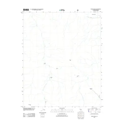
2012 Map of Pleito Hills
USGS Topo · Published 2012About this map
Antimony Peak anchors the southern boundary of this 2012 survey, overlooking a landscape where deep drainage systems and named plateaus define the terrain. The presence of Harris Ranch serves as a lone human marker in an area characterized by significant topographic shifts, from the elevations of the Pleito Hills to the lower expanse of Wheeler Ridge in the north. This map captures the intricate drainage patterns of the Pleito Cr and Salt Cr systems as they carve through the canyons. Notable local landmarks such as Lost Canyon, Neasons Flat, and Joe Clark Flat are precisely documented, providing specific reference points for those studying the physical geography or land-use history of this section of Kern County. In the northeast, Laval Rd skirts the base of the ridge, marking one of the few developed transit corridors in this largely undeveloped area.
Find a feature on this map
11 named features on this map. Tap any name to fly to it.
Don’t see what you’re looking for? This feature index may not catch every label — zoom into the map to look around manually.
Map Details
Editions of this 2012 Pleito Hills Map
This is the sole edition of this map. No revisions or reprints were ever made.
Other maps of this area

1903 · Mt. Pinos
USGS Topo · 1:125,000

1903 · Tejon
USGS Topo · 1:125,000

1910 · Buena Vista Lake
USGS Topo · 1:125,000

1912 · Buena Vista Lake
USGS Topo · 1:125,000

1914 · Caliente
USGS Topo · 1:125,000

1931 · West of Tejon Hills
USGS Topo · 1:31,680

1931 · Hayes Ranch
USGS Topo · 1:31,680

1933 · Hayes Ranch
USGS Topo · 1:31,680
1934 · West of Tejon Hills
USGS Topo · 1:31,680
1934 · Coal Oil Canyon
USGS Topo · 1:31,680