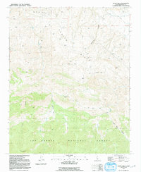
1991 Map of Pleito Hills
USGS Topo · Published 1991About this map
Pleito Hills dominate this portion of the California landscape, where the northern slopes give way to an active Oil Field and numerous oil wells. The terrain is defined by a series of deep drainage systems, including Telegraph Canyon and Pleito Creek, which run toward the valley floor. Evidence of the region's ranching and resource history is scattered throughout, noted by several corral locations and widespread water tanks used for livestock or industrial operations.
Find a feature on this map
19 named features on this map. Tap any name to fly to it.
Don’t see what you’re looking for? This feature index may not catch every label — zoom into the map to look around manually.
Map Details
Editions of this 1991 Pleito Hills Map
This is the sole edition of this map. No revisions or reprints were ever made.
Other maps of this area

1903 · Mt. Pinos
USGS Topo · 1:125,000

1903 · Tejon
USGS Topo · 1:125,000

1910 · Buena Vista Lake
USGS Topo · 1:125,000

1912 · Buena Vista Lake
USGS Topo · 1:125,000

1914 · Caliente
USGS Topo · 1:125,000

1931 · West of Tejon Hills
USGS Topo · 1:31,680

1931 · Hayes Ranch
USGS Topo · 1:31,680

1933 · Hayes Ranch
USGS Topo · 1:31,680
1934 · West of Tejon Hills
USGS Topo · 1:31,680
1934 · Coal Oil Canyon
USGS Topo · 1:31,680