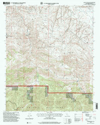
1995 Map of Pleito Hills
USGS Topo · Published 2000About this map
San Emigdio Mountains peaks and steep canyons define this portion of the Los Padres National Forest in southern Kern County. The mid-1990s landscape is a mix of protected wilderness and active industry, where an Oil Field and an Oil Well sit near Wheeler Ridge in the northern reaches. This transition from high-elevation terrain to industrial utility is marked by a complex network of pipelines and service roads cutting through the Pleito Hills.
Find a feature on this map
19 named features on this map. Tap any name to fly to it.
Don’t see what you’re looking for? This feature index may not catch every label — zoom into the map to look around manually.
Map Details
Editions of this 1995 Pleito Hills Map
This is the sole edition of this map. No revisions or reprints were ever made.
Other maps of this area

1903 · Mt. Pinos
USGS Topo · 1:125,000

1903 · Tejon
USGS Topo · 1:125,000

1910 · Buena Vista Lake
USGS Topo · 1:125,000

1912 · Buena Vista Lake
USGS Topo · 1:125,000

1914 · Caliente
USGS Topo · 1:125,000

1931 · West of Tejon Hills
USGS Topo · 1:31,680

1931 · Hayes Ranch
USGS Topo · 1:31,680

1933 · Hayes Ranch
USGS Topo · 1:31,680
1934 · West of Tejon Hills
USGS Topo · 1:31,680

1934 · Coal Oil Canyon
USGS Topo · 1:31,680