
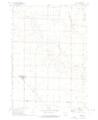
1964 Map of Plessis
USGS Topo · Published 1966About this map
The small unincorporated communities of Plessis and Epping serve as the primary focal points for this mid-1960s agricultural landscape in O'Brien County. The era is defined by the intersection of rail and water, where the Chicago Rock Island and Pacific railroad cuts a diagonal path across the northeastern townships, while the Chicago Milwaukee St Paul and Pacific runs east-to-west through the center of the quadrangle. These rail corridors, alongside the Floyd River and Waterman Creek, historically dictated the placement of local infrastructure, including a Pumping Station and an electrical Substation. The map reveals a highly structured grid of section lines typical of the prairie grain belt, dotted with scattered farmsteads and a local Cem that speak to the generational family settlement of the region. This 1964 survey captures the rural layout before modern agricultural consolidation significantly altered the small-scale field patterns and local drainage features like Mill Creek.
Find a feature on this map
17 named features on this map. Tap any name to fly to it.
Don’t see what you’re looking for? This feature index may not catch every label — zoom into the map to look around manually.
Map Details
Editions of this 1964 Plessis Map
This is the sole edition of this map. No revisions or reprints were ever made.
Other maps of this area

1954 · Fairmont
USGS Topo · 1:250,000

1958 · Fairmont
USGS Topo · 1:250,000

1964 · Primghar
USGS Topo · 1:24,000

1964 · Gaza
USGS Topo · 1:24,000

1964 · Sanborn
USGS Topo · 1:24,000

1970 · Hartley SW
USGS Topo · 1:24,000

1970 · Hartley
USGS Topo · 1:24,000

1970 · May City
USGS Topo · 1:24,000

1972 · Cloverdale
USGS Topo · 1:24,000
1972 · Melvin
USGS Topo · 1:24,000