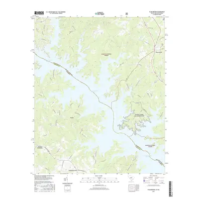
2017 Map of Plum Branch
USGS Topo · Published 2017About this map
Plum Branch and its surrounding rural communities occupy the high ground between the fingers of the J. Strom Thurmond Reservoir along the South Carolina and Georgia border. This landscape is defined by the deep indentations of the reservoir’s shoreline, where the waters of the Savannah River reach into old creek beds like Hawe Cr and Tandem Br. Significant portions of the terrain are managed as part of the Sumter National Forest and the NG MTA Clarks Hill Reservation, preserving a mix of timberland and shoreline. Small settlements like Maxim and Martins Crossroads are linked by a network of local roads such as Chamberlain Ferry Rd and Double Branches Rd, which trace the higher ridges. Genealogists will find several notable local burial sites, including Republican Cem, Pine Grove Cem, and Plum Branch Cem, which anchor the historical record of these upland communities.
Find a feature on this map
68 named features on this map. Tap any name to fly to it.
Don’t see what you’re looking for? This feature index may not catch every label — zoom into the map to look around manually.
Map Details
Editions of this 2017 Plum Branch Map
This is the sole edition of this map. No revisions or reprints were ever made.
Other maps of this area

1892 · Mc Cormick
USGS Topo · 1:125,000

1912 · Mc Cormick
USGS Topo · 1:125,000

1920 · Clarks Hill
USGS Topo · 1:48,000

1921 · Clarks Hill
USGS Topo · 1:62,500

1921 · Appling
USGS Topo · 1:62,500

1941 · Clarks Hill
USGS Topo · 1:62,500

1942 · Clarks Hill
USGS Topo · 1:62,500

1943 · Appling
USGS Topo · 1:62,500

1953 · Athens
USGS Topo · 1:250,000

1958 · Athens
USGS Topo · 1:250,000