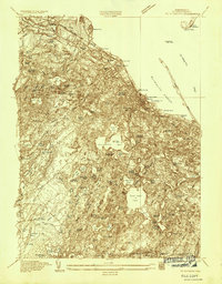
1934 Map of Plymouth
USGS Topo · Published 1934About this map
Plymouth Rock and the surrounding coastal landscape of Plymouth appear in this 1934 survey, reflecting a region deeply defined by its maritime heritage and expanding cranberry industry. The shoreline is punctuated by landmarks such as Coles Hill and the Plymouth National Monument, while further out in the harbor, Fort Standish and the Duxbury Pier Light mark the approach to the bay. The interior of the quadrangle is dominated by a complex network of glacial ponds, including the expansive Billington Sea and Great South Pond.
Find a feature on this map
66 named features on this map. Tap any name to fly to it.
Don’t see what you’re looking for? This feature index may not catch every label — zoom into the map to look around manually.
Map Details
Editions of this 1934 Plymouth Map
This is the sole edition of this map. No revisions or reprints were ever made.
Other maps of this area

1885 · Abington
USGS Topo · 1:62,500

1885 · Duxbury
USGS Topo · 1:62,500

1885 · Middleboro
USGS Topo · 1:62,500

1886 · Plymouth
USGS Topo · 1:62,500

1888 · Duxbury
USGS Topo · 1:62,500

1888 · Middleboro
USGS Topo · 1:62,500

1888 · Abington
USGS Topo · 1:62,500

1889 · Plymouth
USGS Topo · 1:62,500

1893 · Abington
USGS Topo · 1:62,500

1893 · Duxbury
USGS Topo · 1:62,500