
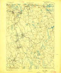
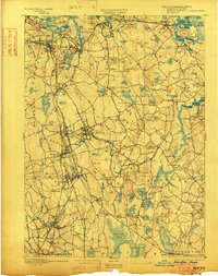
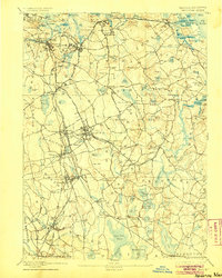
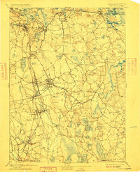
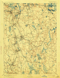
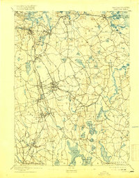
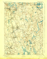
1893 Map of Abington
USGS Topo · Published 1893About this map
The Old Colony Railroad and its South Shore Branch dictate the movement of goods and people across this late-19th-century coastal landscape, connecting established hubs like Weymouth and Hingham to the industrial nodes of Rockland and Abington. While the northern shore is marked by the maritime activity of Weymouth Harbor and Hingham Harbor, the interior reveals a transition from coastal marsh to high points like Prospect Hill and Scituate Hill.
Find a feature on this map
189 named features on this map. Tap any name to fly to it.
Don’t see what you’re looking for? This feature index may not catch every label — zoom into the map to look around manually.
Map Details
Editions of this 1893 Abington Map
9 editions found
Historical Maps of Brockton Through Time
175 maps found

1885 Abington
Plymouth County, MA

1885 Duxbury
Plymouth County, MA

1885 Middleboro
Plymouth County, MA

1886 Plymouth
Plymouth County, MA

1888 Abington
Plymouth County, MA

1888 Duxbury
Plymouth County, MA

1888 Middleboro
Plymouth County, MA

1889 Plymouth
Plymouth County, MA

1893 Abington
Plymouth County, MA

1893 Duxbury
Plymouth County, MA

1893 Middleboro
Plymouth County, MA

1894 Plymouth
Plymouth County, MA

1916 Middleboro
Plymouth County, MA

1918 Duxbury
Plymouth County, MA

1918 Middleboro
Plymouth County, MA

1920 Abington
Plymouth County, MA

1921 Plymouth
Plymouth County, MA

1934 Plymouth
Plymouth County, MA

1935 Hanover
Plymouth County, MA

1935 Scituate
Plymouth County, MA

1935 Wareham
Plymouth County, MA

1936 Cohasset
Plymouth County, MA

1936 Marion
Plymouth County, MA

1936 Nantasket
Plymouth County, MA

1936 Whitman
Plymouth County, MA

1937 Assawompset Pond
Plymouth County, MA

1937 Manomet
Plymouth County, MA

1937 Middleboro
Plymouth County, MA

1937 Plympton
Plymouth County, MA

1938 Snipatuit Pond
Plymouth County, MA

1939 Plymouth
Plymouth County, MA

1939 Wareham
Plymouth County, MA

1940 Bridgewater
Plymouth County, MA

1940 Hanover
Plymouth County, MA

1940 Scituate
Plymouth County, MA

1941 Assawompset Pond
Plymouth County, MA

1941 Cohasset
Plymouth County, MA

1941 Duxbury
Plymouth County, MA

1941 Manomet
Plymouth County, MA

1941 Marion
Plymouth County, MA

1941 Nantasket
Plymouth County, MA

1941 Plympton
Plymouth County, MA

1941 Whitman
Plymouth County, MA

1942 Snipatuit Pond
Plymouth County, MA

1943 Marion
Plymouth County, MA

1943 Plymouth
Plymouth County, MA

1946 Wareham
Plymouth County, MA

1947 Cohasset
Plymouth County, MA

1947 Duxbury
Plymouth County, MA

1947 Scituate
Plymouth County, MA

1948 Assawompset Pond
Plymouth County, MA

1948 Hanover
Plymouth County, MA

1948 Whitman
Plymouth County, MA

1949 Bridgewater
Plymouth County, MA

1949 Nantasket
Plymouth County, MA

1949 Plympton
Plymouth County, MA

1949 Snipatuit Pond
Plymouth County, MA

1950 Plymouth
Plymouth County, MA

1953 Duxbury
Plymouth County, MA

1957 Wareham
Plymouth County, MA

1961 Cohasset
Plymouth County, MA

1961 Duxbury
Plymouth County, MA

1961 Nantasket Beach
Plymouth County, MA

1961 Scituate
Plymouth County, MA

1962 Bridgewater
Plymouth County, MA

1962 Hanover
Plymouth County, MA

1962 Manomet
Plymouth County, MA

1962 Marion
Plymouth County, MA

1962 Plymouth
Plymouth County, MA

1962 Plympton
Plymouth County, MA

1962 Snipatuit Pond
Plymouth County, MA

1962 Whitman
Plymouth County, MA

1963 Assawompset Pond
Plymouth County, MA

1972 Wareham
Plymouth County, MA

1974 Cohasset
Plymouth County, MA

1974 Duxbury
Plymouth County, MA

1974 Nantasket Beach
Plymouth County, MA

1974 Scituate
Plymouth County, MA

1977 Assawompset Pond
Plymouth County, MA

1977 Bridgewater
Plymouth County, MA

1977 Cohasset
Plymouth County, MA

1977 Duxbury
Plymouth County, MA

1977 Hanover
Plymouth County, MA

1977 Manomet
Plymouth County, MA

1977 Marion
Plymouth County, MA

1977 Nantasket Beach
Plymouth County, MA

1977 Plymouth
Plymouth County, MA

1977 Plympton
Plymouth County, MA

1977 Scituate
Plymouth County, MA

1977 Snipatuit Pond
Plymouth County, MA

1977 Wareham
Plymouth County, MA

1977 Whitman
Plymouth County, MA

1978 Assawompset Pond
Plymouth County, MA

1978 Hanover
Plymouth County, MA

1984 Hull
Plymouth County, MA

1984 Provincetown
Plymouth County, MA

1984 Scituate
Plymouth County, MA

1984 Weymouth
Plymouth County, MA

1997 Assawompset Pond
Plymouth County, MA

1997 Hull
Plymouth County, MA

2012 Assawompset Pond
Plymouth County, MA

2012 Bridgewater
Plymouth County, MA

2012 Cohasset
Plymouth County, MA

2012 Duxbury OE E
Plymouth County, MA

2012 Duxbury
Plymouth County, MA

2012 Hanover
Plymouth County, MA

2012 Manomet
Plymouth County, MA

2012 Marion
Plymouth County, MA

2012 Nantasket Beach
Plymouth County, MA

2012 Plymouth
Plymouth County, MA

2012 Plympton
Plymouth County, MA

2012 Scituate
Plymouth County, MA

2012 Snipatuit Pond
Plymouth County, MA

2012 Wareham
Plymouth County, MA

2012 Whitman
Plymouth County, MA

2015 Assawompset Pond
Plymouth County, MA

2015 Bridgewater
Plymouth County, MA

2015 Cohasset
Plymouth County, MA

2015 Duxbury OE E
Plymouth County, MA

2015 Duxbury
Plymouth County, MA

2015 Hanover
Plymouth County, MA

2015 Manomet
Plymouth County, MA

2015 Marion
Plymouth County, MA

2015 Nantasket Beach
Plymouth County, MA

2015 Plymouth
Plymouth County, MA

2015 Plympton
Plymouth County, MA

2015 Scituate
Plymouth County, MA

2015 Snipatuit Pond
Plymouth County, MA

2015 Wareham
Plymouth County, MA

2015 Whitman
Plymouth County, MA

2018 Assawompset Pond
Plymouth County, MA

2018 Bridgewater
Plymouth County, MA

2018 Cohasset
Plymouth County, MA

2018 Duxbury OE E
Plymouth County, MA

2018 Duxbury
Plymouth County, MA

2018 Hanover
Plymouth County, MA

2018 Manomet
Plymouth County, MA

2018 Marion
Plymouth County, MA

2018 Nantasket Beach
Plymouth County, MA

2018 Plymouth
Plymouth County, MA

2018 Plympton
Plymouth County, MA

2018 Scituate
Plymouth County, MA

2018 Snipatuit Pond
Plymouth County, MA

2018 Wareham
Plymouth County, MA

2018 Whitman
Plymouth County, MA

2021 Assawompset Pond
Plymouth County, MA

2021 Bridgewater
Plymouth County, MA

2021 Cohasset
Plymouth County, MA

2021 Duxbury OE E
Plymouth County, MA

2021 Duxbury
Plymouth County, MA

2021 Hanover
Plymouth County, MA

2021 Manomet
Plymouth County, MA

2021 Marion
Plymouth County, MA

2021 Nantasket Beach
Plymouth County, MA

2021 Plymouth
Plymouth County, MA

2021 Plympton
Plymouth County, MA

2021 Scituate
Plymouth County, MA

2021 Snipatuit Pond
Plymouth County, MA

2021 Wareham
Plymouth County, MA

2021 Whitman
Plymouth County, MA

2024 Assawompset Pond
Plymouth County, MA

2024 Bridgewater
Plymouth County, MA

2024 Cohasset
Plymouth County, MA

2024 Duxbury OE E
Plymouth County, MA

2024 Duxbury
Plymouth County, MA

2024 Hanover
Plymouth County, MA

2024 Manomet
Plymouth County, MA

2024 Marion
Plymouth County, MA

2024 Nantasket Beach
Plymouth County, MA

2024 Plymouth
Plymouth County, MA

2024 Plympton
Plymouth County, MA

2024 Scituate
Plymouth County, MA

2024 Snipatuit Pond
Plymouth County, MA

2024 Wareham
Plymouth County, MA

2024 Whitman
Plymouth County, MA