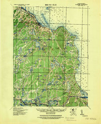
1943 Map of Plymouth
USGS Topo · Published 1943About this map
The town of Plymouth and its coastal surroundings are documented here in detail, showing a landscape defined by glacial ponds and maritime navigation at the onset of the 1940s. Beyond the historic center, the terrain is dotted with significant water bodies like Billington Sea and the massive Great South Pond, while the shoreline is marked by prominent nautical landmarks including Saquish Head and Manomet Pt.. The interior reveals a complex network of woods and waterways, such as the Eel River and numerous named kettle ponds that supported early regional growth.
Find a feature on this map
126 named features on this map. Tap any name to fly to it.
Don’t see what you’re looking for? This feature index may not catch every label — zoom into the map to look around manually.
Map Details
Editions of this 1943 Plymouth Map
This is the sole edition of this map. No revisions or reprints were ever made.
Other maps of this area

1885 · New Bedford
USGS Topo · 1:62,500

1885 · Abington
USGS Topo · 1:62,500

1885 · Duxbury
USGS Topo · 1:62,500

1885 · Middleboro
USGS Topo · 1:62,500

1886 · Falmouth
USGS Topo · 1:62,500

1886 · Plymouth
USGS Topo · 1:62,500

1888 · Duxbury
USGS Topo · 1:62,500

1888 · Barnstable
USGS Topo · 1:62,500

1888 · New Bedford
USGS Topo · 1:62,500

1888 · Falmouth
USGS Topo · 1:62,500