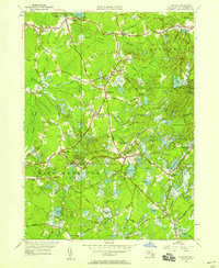
1949 Map of Plympton
USGS Topo · Published 1958About this map
The Winnetuxet River and its numerous tributaries define this corner of Plymouth County, where a complex network of wetlands and cranberry bogs supports the local economy. At the time of this mid-century revision, the Plymouth Branch of the New York New Haven and Hartford Railroad still provided a vital link through Halifax, connecting the scattered settlements of Plympton, Eddyville, and North Carver.
Find a feature on this map
92 named features on this map. Tap any name to fly to it.
Don’t see what you’re looking for? This feature index may not catch every label — zoom into the map to look around manually.
Map Details
Editions of this 1949 Plympton Map
This is the sole edition of this map. No revisions or reprints were ever made.
Other maps of this area

1885 · Abington
USGS Topo · 1:62,500

1885 · Duxbury
USGS Topo · 1:62,500

1885 · Middleboro
USGS Topo · 1:62,500

1886 · Plymouth
USGS Topo · 1:62,500

1888 · Duxbury
USGS Topo · 1:62,500

1888 · Middleboro
USGS Topo · 1:62,500

1888 · Abington
USGS Topo · 1:62,500

1889 · Plymouth
USGS Topo · 1:62,500

1893 · Abington
USGS Topo · 1:62,500

1893 · Duxbury
USGS Topo · 1:62,500