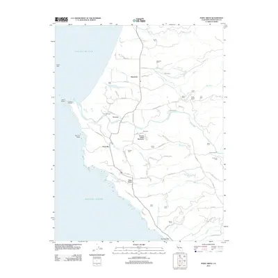
2012 Map of Point Arena
USGS Topo · Published 2012About this map
The Point Arena Lighthouse stands as a primary landmark along this stretch of the Mendocino coast, marking the sharp western projection into the Pacific Ocean. The landscape transitions from the coastal bluffs of Arena Cove to the pastoral dairy lands and ranching properties that define the interior. Named holdings such as Hillcrest Dairy, Baggi Ranch, and Lepori Ranch reflect a long-standing agricultural tradition, while the Iverson Indian Rancheria signifies a distinct cultural footprint near the banks of the Garcia River. The settlement pattern follows the coastal terrace, with Manchester and Stronetta situated along the main thoroughfare. Moving inland, the terrain is carved by numerous drainages including Brush Cr and Moat Cr, providing a look at the intersection of maritime navigation and rural northern California industry in the early 21st century.
Find a feature on this map
68 named features on this map. Tap any name to fly to it.
Don’t see what you’re looking for? This feature index may not catch every label — zoom into the map to look around manually.
Map Details
Editions of this 2012 Point Arena Map
This is the sole edition of this map. No revisions or reprints were ever made.
Other maps of this area

1943 · Point Arena
USGS Topo · 1:62,500

1943 · Albion
USGS Topo · 1:62,500

1943 · Navarro
USGS Topo · 1:62,500

1944 · Saddle Point
USGS Topo · 1:62,500

1947 · Santa Rosa
USGS Topo · 1:250,000

1949 · Santa Rosa
USGS Topo · 1:250,000

1957 · Ukiah
USGS Topo · 1:250,000

1958 · Santa Rosa
USGS Topo · 1:250,000

1960 · Ukiah
USGS Topo · 1:250,000

1960 · Saunders Reef
USGS Topo · 1:24,000