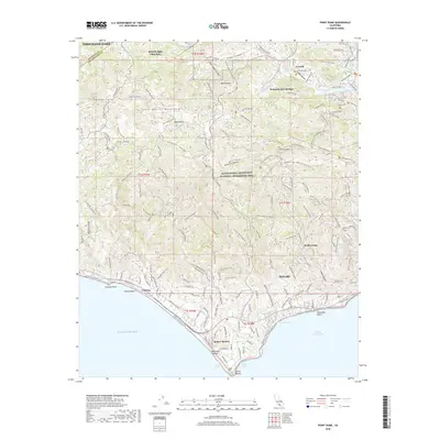
2018 Map of Point Dume
USGS Topo · Published 2018About this map
The Santa Monica Mountains National Recreation Area dominates this coastal landscape, where high peaks like Castro Peak and Ballard Mtn overlook the Pacific. The southern shoreline is defined by the prominent headland of Point Dume, separating Dume Cove and Pirates Cove from the long stretch of Trancas Beach. Inland, the map reveals the complex road and trail network that serves communities like Seminole Hot Springs and Cornell, including segments of the California Coastal Trail and the Backbone Trail. This 2018 survey captures the modern interface between dense residential developments such as Malibu Vista and Mahou Riviera and the expansive protected wildlands of the Santa Monica Mountains. The presence of Lake Enchanto near the northern border suggests the recreational legacy of the canyons before they transition into the suburban reaches of Thousand Oaks and Westlake Village.
Find a feature on this map
41 named features on this map. Tap any name to fly to it.
Don’t see what you’re looking for? This feature index may not catch every label — zoom into the map to look around manually.
Map Details
Editions of this 2018 Point Dume Map
This is the sole edition of this map. No revisions or reprints were ever made.
Other maps of this area

1900 · Triunfo Pass
USGS Topo · 1:62,500

1903 · Calabasas
USGS Topo · 1:62,500

1903 · Camulos
USGS Topo · 1:125,000

1921 · Triunfo Pass
USGS Topo · 1:62,500

1929 · Dume Point
USGS Topo · 1:24,000

1929 · Vejor
USGS Topo · 1:24,000

1929 · Solstice Canyon
USGS Topo · 1:24,000

1932 · Dume Point
USGS Topo · 1:24,000

1932 · Seminole
USGS Topo · 1:24,000

1932 · Russell Valley
USGS Topo · 1:24,000
Featured Places
- Thousand Oaks, CA
- Malibu, CA
- Westlake Village, CA
- Unincorporated Santa Monica Mountains, CA
- Trancas, Malibu