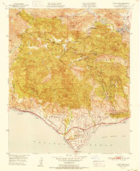
1951 Map of Point Dume
USGS Topo · Published 1951About this map
The Santa Monica Mountains dominate this 1950s landscape, where winding canyon roads like the Mulholland Highway connect isolated mountain communities and coastal retreats. This era captures the area before the era of intensive suburban development, showcasing a network of private clubs and seasonal destinations like the Malibu Lake Mtn Club and Seminole Hot Springs. Along the coast, the topography drops sharply toward the Pacific Ocean, defined by landmarks such as Point Dume and the established Zuma Beach County Park. Local life is anchored by small inland settlements like Cornell, home to the Cornell Sch, while newer coastal developments like Malibu Riviera and Malibu Vista suggest the growing appeal of the shoreline. The map reveals a transition from ranching heritage at Kincaid Ranch to a recreation-based economy centered around Malibu Lake and the various beaches.
Find a feature on this map
47 named features on this map. Tap any name to fly to it.
Don’t see what you’re looking for? This feature index may not catch every label — zoom into the map to look around manually.
Map Details
Editions of this 1951 Point Dume Map
This is the sole edition of this map. No revisions or reprints were ever made.
Other maps of this area

1900 · Triunfo Pass
USGS Topo · 1:62,500

1903 · Calabasas
USGS Topo · 1:62,500

1903 · Camulos
USGS Topo · 1:125,000

1921 · Triunfo Pass
USGS Topo · 1:62,500

1929 · Dume Point
USGS Topo · 1:24,000

1929 · Vejor
USGS Topo · 1:24,000

1929 · Solstice Canyon
USGS Topo · 1:24,000

1932 · Dume Point
USGS Topo · 1:24,000

1932 · Seminole
USGS Topo · 1:24,000

1932 · Russell Valley
USGS Topo · 1:24,000
Featured Places
- Thousand Oaks, CA
- Malibu, CA
- Westlake Village, CA
- Cornell, Unincorporated Santa Monica Mountains
- Malibu Vista, Unincorporated Santa Monica Mountains