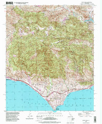
1995 Map of Point Dume
USGS Topo · Published 1999About this map
The Santa Monica Mountains define this stretch of the Pacific coast, where deep canyons like Zuma Canyon and Solstice Canyon descend toward the sea. By the mid-1990s, the area shows a distinct contrast between the vast protected lands of the Santa Monica Mountains National Recreation Area and the emerging residential clusters along the shore. Pockets of development such as Malibu Riviera and Malibu Vista sit tucked between the coastline and the steep ridges. High-elevation landmarks like the Castro Pk Lookout and Saddle Rock watch over the winding Mulholland Hwy. Along the shoreline, recreational hubs like Paradise Cove and the prominent Point Dume serve as anchors for a landscape increasingly oriented toward conservation and high-end coastal living, while inland sites like Seminole Hot Springs recall the region's diverse geology.
Find a feature on this map
42 named features on this map. Tap any name to fly to it.
Don’t see what you’re looking for? This feature index may not catch every label — zoom into the map to look around manually.
Map Details
Editions of this 1995 Point Dume Map
This is the sole edition of this map. No revisions or reprints were ever made.
Other maps of this area

1900 · Triunfo Pass
USGS Topo · 1:62,500

1903 · Calabasas
USGS Topo · 1:62,500

1903 · Camulos
USGS Topo · 1:125,000

1921 · Triunfo Pass
USGS Topo · 1:62,500

1929 · Dume Point
USGS Topo · 1:24,000

1929 · Vejor
USGS Topo · 1:24,000

1929 · Solstice Canyon
USGS Topo · 1:24,000

1932 · Dume Point
USGS Topo · 1:24,000

1932 · Seminole
USGS Topo · 1:24,000

1932 · Russell Valley
USGS Topo · 1:24,000
Featured Places
- Thousand Oaks, CA
- Malibu, CA
- Westlake Village, CA
- Cornell, Unincorporated Santa Monica Mountains
- Malibu Vista, Unincorporated Santa Monica Mountains