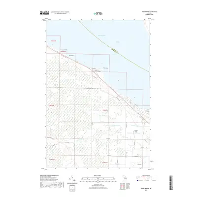
2019 Map of Point Nipigon
USGS Topo · Published 2019About this map
Point Nipigon and Grand View occupy the shoreline where the Straits of Mackinac meet the South Channel of Lake Huron. This 2019 survey documents a landscape defined by the transition from coastal resort areas to the low-lying wetlands of the interior. The N Central State Trail follows a former railroad alignment along the coast, illustrating the area's shift from industrial transport to modern recreational use. Further inland, the drainage systems of the Little Black River and the W Br Little Black River carve through the terrain, punctuated by features like Mud Lake and Stony Point. Infrastructure such as the Cheboygan County Airport and a network of rural routes, including the Hebron Mail Route Rd and Old Mackinaw Rd, connect the scattered settlements and agricultural lands of the northern Lower Peninsula.
Find a feature on this map
46 named features on this map. Tap any name to fly to it.
Don’t see what you’re looking for? This feature index may not catch every label — zoom into the map to look around manually.
Map Details
Editions of this 2019 Point Nipigon Map
This is the sole edition of this map. No revisions or reprints were ever made.
Other maps of this area

1955 · Cheboygan
USGS Topo · 1:250,000

1957 · Cheboygan
USGS Topo · 1:62,500

1957 · Mullett Lake
USGS Topo · 1:62,500

1958 · Cheboygan
USGS Topo · 1:250,000

1964 · Round Island
USGS Topo · 1:24,000
1964 · St. Ignace
USGS Topo · 1:24,000

1964 · McRae Bay
USGS Topo · 1:24,000

1982 · Cheboygan
USGS Topo · 1:25,000

1982 · Point Nipigon
USGS Topo · 1:25,000

1982 · Aloha
USGS Topo · 1:25,000