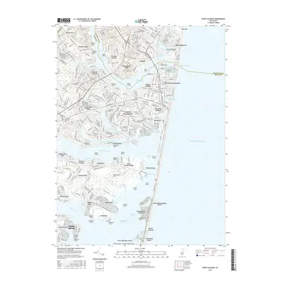
2016 Map of Point Pleasant
USGS Topo · Published 2016About this map
The Manasquan River serves as a natural divide between Monmouth and Ocean Counties, anchoring a landscape defined by coastal lagoons and tidal inlets. Along its northern banks, the settlements of Manasquan and Brielle lead toward the Manasquan Inlet, a vital passage to the Atlantic Ocean. To the south, the Intracoastal Waterway winds through Barnegat Bay, passing Osborn Island and reaching the resort communities of Point Pleasant Beach and Bay Head. This 2016 survey documents the intricate network of water and land, from the residential grids of Shore Acres and Baywood near Kettle Creek to the narrow barrier island home to Mantoloking and Normandy Beach. Local landmarks like the Glimmer Glass Bridge and the historic Bay Head Junction highlight the transport legacy of this Jersey Shore corridor. Further inland, the Metedeconk River feeds into the bay near Wardells Neck, while older sites like Greenwood Cem provide genealogical context amidst the modern suburban expansion of Herbertsville and Allenwood.
Find a feature on this map
94 named features on this map. Tap any name to fly to it.
Don’t see what you’re looking for? This feature index may not catch every label — zoom into the map to look around manually.
Map Details
Editions of this 2016 Point Pleasant Map
This is the sole edition of this map. No revisions or reprints were ever made.
Other maps of this area

1888 · Barnegat
USGS Topo · 1:62,500

1888 · Asbury Park
USGS Topo · 1:62,500

1893 · Asbury Park
USGS Topo · 1:62,500

1893 · Barnegat
USGS Topo · 1:62,500

1898 · Barnegat
USGS Topo · 1:62,500

1901 · Asbury Park
USGS Topo · 1:62,500

1902 · Navesink
USGS Topo · 1:125,000

1919 · Barnegat
USGS Topo · 1:62,500

1919 · Asbury Park
USGS Topo · 1:62,500

1941 · Toms River
USGS Topo · 1:62,500