1943 Map of Pompton Plains
USGS Topo · Published 1947About this map
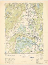
Pompton Plains and Pequannock sit within a valley defined by the winding course of the Passaic River and the Pequannock River. This mid-century landscape is notable for its concentration of early aviation facilities, including North Jersey Airport, Murchia Airport, and Lincoln Park Airport, which served the region's growing industrial and transport needs. To the west, the terrain rises sharply toward Bald Hill and Hook Mountain, where the Butler Reservoir and Fayson Lakes reflect the area's development of water resources and recreational enclaves.
Find a feature on this map
50 named features on this map. Tap any name to fly to it.
Don’t see what you’re looking for? This feature index may not catch every label — zoom into the map to look around manually.
Map Details
Editions of this 1943 Pompton Plains Map
This is the sole edition of this map. No revisions or reprints were ever made.
Other maps of this area

1888 · Morristown
USGS Topo · 1:62,500

1888 · Paterson
USGS Topo · 1:62,500

1891 · Greenwood Lake
USGS Topo · 1:62,500

1891 · Ramapo
USGS Topo · 1:62,500

1892 · Paterson
USGS Topo · 1:62,500

1893 · Greenwood Lake
USGS Topo · 1:62,500

1893 · Ramapo
USGS Topo · 1:62,500

1894 · Morristown
USGS Topo · 1:62,500

1898 · Morristown
USGS Topo · 1:62,500

1898 · Paterson
USGS Topo · 1:62,500