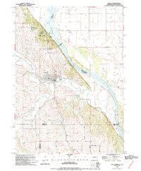
1994 Map of Ponca
USGS Topo · Published 1994About this map
Ponca serves as the focal point of this northeast Nebraska landscape, situated near the dramatic bluffs overlooking the Missouri River. The town's layout is well-defined, showing residential blocks and local landmarks like Mattison Park and the Ponca Cem. Just to the north, the varied topography of Ponca State Park rises above the riverbanks, featuring Lookout Hill and an Aboveground Pipeline crossing the water toward South Dakota. The surrounding terrain is deeply etched by the drainage systems of Aowa Creek, North Aowa Creek, and South Aowa Creek. This 1990s revision captures the area at a time when traditional agricultural land use intersected with conservation at the state park and industrial utility markers like the Gaging Sta. Across the river, the broad floodplain of Civil Bend in Union County, South Dakota, provides a stark contrast to the Nebraska bluffs.
Find a feature on this map
23 named features on this map. Tap any name to fly to it.
Don’t see what you’re looking for? This feature index may not catch every label — zoom into the map to look around manually.
Map Details
Editions of this 1994 Ponca Map
This is the sole edition of this map. No revisions or reprints were ever made.
Other maps of this area

1898 · Elk Point
USGS Topo · 1:125,000

1901 · Elk Point
USGS Topo · 1:125,000

1907 · Elk Point
USGS Topo · 1:125,000

1955 · Sioux City
USGS Topo · 1:250,000

1958 · Sioux City
USGS Topo · 1:250,000

1959 · Sioux City
USGS Topo · 1:250,000

1963 · Elk Point
USGS Topo · 1:24,000

1963 · Elk Point NE
USGS Topo · 1:24,000

1963 · Jefferson
USGS Topo · 1:24,000

1964 · Burbank
USGS Topo · 1:24,000
Featured Places
- Ponca, NE
- St. Johns Precinct, NE
- Ottercreek Township, NE
- Civil Bend Township, SD
- Hoffmans Trailer Court, SD