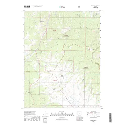
2019 Map of Poncha Pass
USGS Topo · Published 2019About this map
Poncha Pass serves as a critical geographic divide on this 2019 survey, marking the intersection of the Chaffee, Fremont, and Saguache county lines. This high mountain corridor facilitates travel between the northern Arkansas River Valley and the San Luis Valley to the south, with Poncha Creek and San Luis Creek draining in opposite directions from the summit. The area is defined by the transition between the San Isabel National Forest and Rio Grande National Forest, where steep gulches like Dry Lake Gulch and Sand Gulch cut through the slopes of Cleveland Mountain and Poncha Mountain. Cultural landmarks are centered near the pass, including the Granite Mountain Lodge Airport and the geothermal waters of Poncha Hot Springs. Further into the high country, Methodist Mountain and Simmons Peak anchor a landscape dotted with secluded water features like Salamander Lake and Wicker Spring.
Find a feature on this map
50 named features on this map. Tap any name to fly to it.
Don’t see what you’re looking for? This feature index may not catch every label — zoom into the map to look around manually.
Map Details
Editions of this 2019 Poncha Pass Map
This is the sole edition of this map. No revisions or reprints were ever made.
Other maps of this area

1954 · Pueblo
USGS Topo · 1:250,000

1956 · Cameron Mountain
USGS Topo · 1:62,500

1956 · Poncha Springs
USGS Topo · 1:62,500

1956 · Montrose
USGS Topo · 1:250,000

1957 · Pueblo
USGS Topo · 1:250,000

1958 · Pueblo
USGS Topo · 1:250,000

1959 · Montrose
USGS Topo · 1:250,000

1959 · Bonanza
USGS Topo · 1:62,500

1959 · Howard
USGS Topo · 1:62,500

1960 · Montrose
USGS Topo · 1:250,000