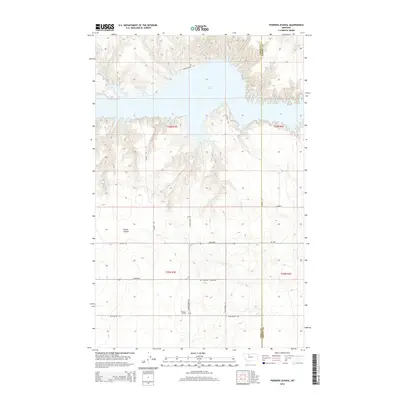
2014 Map of Pondera School
USGS Topo · Published 2014About this map
Lake Elwell dominates the northern reaches of this landscape on the border of Toole and Liberty counties. The terrain is defined by the deep incisions of Timber Coulee and the surrounding draws that feed toward the Marias River drainage. This 2014 survey documents a sparsely populated ranching and agricultural region, where the historical namesake Pondera School stands as a focal point for the surrounding homesteads.
Find a feature on this map
20 named features on this map. Tap any name to fly to it.
Don’t see what you’re looking for? This feature index may not catch every label — zoom into the map to look around manually.
Map Details
Editions of this 2014 Pondera School Map
This is the sole edition of this map. No revisions or reprints were ever made.
Other maps of this area

1954 · Shelby
USGS Topo · 1:250,000

1958 · Shelby
USGS Topo · 1:250,000

1970 · Carlson Coulee
USGS Topo · 1:24,000

1970 · Knees NE
USGS Topo · 1:24,000

1970 · Sollid School
USGS Topo · 1:24,000

1970 · Pondera School
USGS Topo · 1:24,000

1970 · Devon
USGS Topo · 1:24,000

1970 · Galata
USGS Topo · 1:24,000
1970 · Denson Ranch
USGS Topo · 1:24,000

1970 · Lothair SW
USGS Topo · 1:24,000