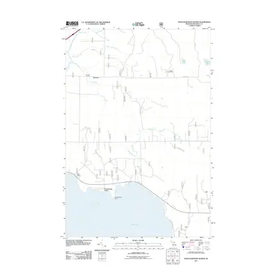
2011 Map of Pontchartrain Shores
USGS Topo · Published 2011About this map
Saint Martin Bay dominates the southern reaches of this Mackinac County landscape, where the waters of Lake Huron meet the forested shoreline at Pontchartrain Point. The inland terrain is defined by a dense network of waterways including the Pine River, Nunns Creek, and Rock Spring Creek, which cut through the level topography. Human settlement is clustered around Pontchartrain Shores and the community of Simmons, the latter associated with the Simmons Cemetery. To the west, near the shore, the Indian Village Cemetery reflects the cultural history of the area. The presence of the Daggett Lookout Tower near Simmons Rd highlights the region's managed forest character. Small inland bodies of water like Cedar Lake and Round Lake sit near the eastern boundary, connected by a system of local routes such as Fish Rd and Saint Ignace Rd.
Find a feature on this map
23 named features on this map. Tap any name to fly to it.
Don’t see what you’re looking for? This feature index may not catch every label — zoom into the map to look around manually.
Map Details
Editions of this 2011 Pontchartrain Shores Map
This is the sole edition of this map. No revisions or reprints were ever made.
Other maps of this area

1931 · St Ignace NW
USGS Topo · 1:31,680

1932 · St Ignace NE
USGS Topo · 1:31,680

1953 · Pickford NW
USGS Topo · 1:24,000
1953 · Rudyard
USGS Topo · 1:24,000

1953 · Fibre
USGS Topo · 1:24,000

1954 · Sault Sainte Marie
USGS Topo · 1:250,000

1955 · Cheboygan
USGS Topo · 1:250,000

1956 · Sault Sainte Marie
USGS Topo · 1:250,000

1957 · Sault Sainte Marie
USGS Topo · 1:250,000

1958 · Cheboygan
USGS Topo · 1:250,000
Featured Places
- Marquette Township, MI
- Simmons, MI
- Pontchartrain Shores, MI
- Saint Ignace Township, MI
- Mackinac County, MI