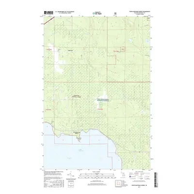
2017 Map of Pontchartrain Shores
USGS Topo · Published 2017About this map
Saint Martin Bay and the northern reaches of Lake Huron define the southern edge of this Mackinac County landscape. The coastal community of Pontchartrain Shores sits near Pontchartrain Point, while the inland settlement of Simmons is situated further north along the Pine River. Much of the interior is dominated by the Hiawatha National Forest and lands managed by the Farm Service Agency Interest of Michigan, creating a terrain characterized by creek networks and small lakes.
Find a feature on this map
24 named features on this map. Tap any name to fly to it.
Don’t see what you’re looking for? This feature index may not catch every label — zoom into the map to look around manually.
Map Details
Editions of this 2017 Pontchartrain Shores Map
This is the sole edition of this map. No revisions or reprints were ever made.
Other maps of this area

1931 · St Ignace NW
USGS Topo · 1:31,680

1932 · St Ignace NE
USGS Topo · 1:31,680

1953 · Pickford NW
USGS Topo · 1:24,000
1953 · Rudyard
USGS Topo · 1:24,000

1953 · Fibre
USGS Topo · 1:24,000

1954 · Sault Sainte Marie
USGS Topo · 1:250,000

1955 · Cheboygan
USGS Topo · 1:250,000

1956 · Sault Sainte Marie
USGS Topo · 1:250,000

1957 · Sault Sainte Marie
USGS Topo · 1:250,000

1958 · Cheboygan
USGS Topo · 1:250,000
Featured Places
- Marquette Township, MI
- Simmons, MI
- Pontchartrain Shores, MI
- Saint Ignace Township, MI
- Mackinac County, MI