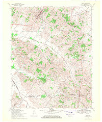
1969 Map of Poole
USGS Topo · Published 1971About this map
The Illinois Central Railroad cuts across the northern landscape of this Kentucky region, connecting the community of Corydon to the broader agricultural and industrial network of Henderson County. The town site is well-developed with the Corydon Sch and Corydon Ch serving as central landmarks, while the County Home sits just to the east. Further south, the map reveals a shift toward resource extraction, marked by a sprawling Oil and Gas Field and a significant Underground Gas Storage Field that dominates the central terrain.
Find a feature on this map
50 named features on this map. Tap any name to fly to it.
Don’t see what you’re looking for? This feature index may not catch every label — zoom into the map to look around manually.
Map Details
Editions of this 1969 Poole Map
This is the sole edition of this map. No revisions or reprints were ever made.
Other maps of this area

1906 · Sebree
USGS Topo · 1:62,500

1907 · Morganfield
USGS Topo · 1:62,500

1914 · Henderson
USGS Topo · 1:48,000

1916 · Henderson
USGS Topo · 1:62,500

1917 · Uniontown
USGS Topo · 1:62,500

1949 · Sebree
USGS Topo · 1:24,000

1949 · Poole
USGS Topo · 1:24,000

1949 · Robards
USGS Topo · 1:24,000

1951 · Dixon
USGS Topo · 1:24,000

1951 · Poole
USGS Topo · 1:24,000