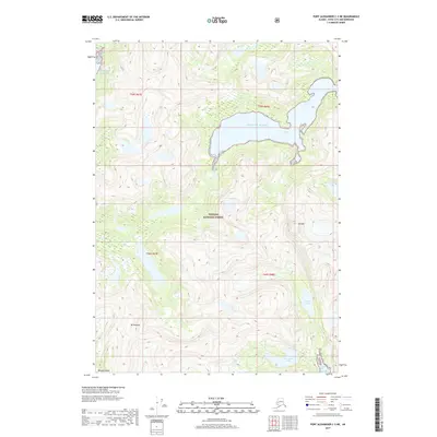
2017 Map of Port Alexander C-3 NE
USGS Topo · Published 2017About this map
Tongass National Forest dominates this coastal landscape on Baranof Island, where the terrain rises sharply from the Gulf of Alaska. The prominent indentation of Gut Bay serves as a central geographic feature, nearly bisecting the island's eastern coastline in this sector. Interior peaks such as Mt Ada and Mt Yanovski define the high ridgelines, which are separated by deep-set glacial lakes including Yermak Lake, Parry Lake, and Brentwood Lake. This 2017 survey by the U.S. Geological Survey illustrates a primitive wilderness devoid of modern roads or settlements, highlighting the complex hydrography and steep elevation gradients characteristic of Southeast Alaska. The map provides a precise look at the natural boundaries between dense forest and the exposed rock of the high summits.
Find a feature on this map
13 named features on this map. Tap any name to fly to it.
Don’t see what you’re looking for? This feature index may not catch every label — zoom into the map to look around manually.
Map Details
Editions of this 2017 Port Alexander C-3 NE Map
This is the sole edition of this map. No revisions or reprints were ever made.
Other maps of this area

1951 · Port Alexander C-2
USGS Topo · 1:63,360

1951 · Port Alexander C-3
USGS Topo · 1:63,360

1951 · Port Alexander D-3
USGS Topo · 1:63,360

1951 · Port Alexander
USGS Topo · 1:250,000

1951 · Port Alexander D-2
USGS Topo · 1:63,360

1952 · Port Alexander
USGS Topo · 1:250,000

1964 · Port Alexander
USGS Topo · 1:250,000

1994 · Port Alexander C-3
USGS Topo · 1:63,360
1995 · Port Alexander D-3
USGS Topo · 1:63,360
1995 · Port Alexander D-2
USGS Topo · 1:63,360