
1994 Map of Port Alexander C-3
USGS Topo · Published 1998About this map
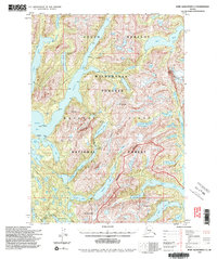
The South Baranof Wilderness on Baranof Island is defined by its deep coastal fjords and dramatic glacial topography. This interior view of the Tongass National Forest showcases a network of massive water bodies including Great Arm, Whale Bay, and Patterson Bay that cut deep into the mountain range. Remote Forest Service infrastructure is documented here, including the Avoss Lake Cabin (FS), Davidof Lake Cabin (FS), and Plotnikof Lake Cabin (FS), alongside the Davidof Trail.
Find a feature on this map
39 named features on this map. Tap any name to fly to it.
Don’t see what you’re looking for? This feature index may not catch every label — zoom into the map to look around manually.
Map Details
Editions of this 1994 Port Alexander C-3 Map
2 editions found
Historical Maps of Sitka Through Time
247 maps found

1948 Port Alexander A-2
Sitka Borough, AK

1948 Port Alexander A-3
Sitka Borough, AK

1948 Port Alexander B-2
Sitka Borough, AK

1948 Sitka A-3
Sitka Borough, AK

1948 Sitka A-5
Sitka Borough, AK

1948 Sitka B-3
Sitka Borough, AK

1948 Sitka B-5
Sitka Borough, AK

1948 Sitka C-3
Sitka Borough, AK

1948 Sitka C-6
Sitka Borough, AK

1948 Sitka C-7
Sitka Borough, AK

1948 Sitka D-6
Sitka Borough, AK

1951 Port Alexander A-2
Sitka Borough, AK

1951 Port Alexander A-3
Sitka Borough, AK

1951 Port Alexander B-2
Sitka Borough, AK

1951 Port Alexander B-3 and B-4
Sitka Borough, AK

1951 Port Alexander C-2
Sitka Borough, AK

1951 Port Alexander C-3
Sitka Borough, AK

1951 Port Alexander C-4
Sitka Borough, AK

1951 Port Alexander D-3
Sitka Borough, AK

1951 Port Alexander D-4
Sitka Borough, AK

1951 Port Alexander D-5
Sitka Borough, AK

1951 Port Alexander
Sitka Borough, AK

1951 Sitka A-3
Sitka Borough, AK

1951 Sitka A-4
Sitka Borough, AK

1951 Sitka A-5
Sitka Borough, AK

1951 Sitka A-6
Sitka Borough, AK

1951 Sitka B-3
Sitka Borough, AK

1951 Sitka B-4
Sitka Borough, AK

1951 Sitka B-5
Sitka Borough, AK

1951 Sitka B-6
Sitka Borough, AK

1951 Sitka C-3
Sitka Borough, AK

1951 Sitka C-4
Sitka Borough, AK

1951 Sitka C-5
Sitka Borough, AK

1951 Sitka C-6
Sitka Borough, AK

1951 Sitka C-7
Sitka Borough, AK

1951 Sitka D-6
Sitka Borough, AK

1952 Port Alexander
Sitka Borough, AK

1954 Sitka A-4
Sitka Borough, AK

1964 Port Alexander
Sitka Borough, AK

1987 Sitka A-4 SW
Sitka Borough, AK

1987 Sitka A-5 SE
Sitka Borough, AK
1994 Port Alexander C-3
Sitka Borough, AK

1994 Port Alexander C-4
Sitka Borough, AK

1994 Sitka C-7
Sitka Borough, AK

1995 Port Alexander D-3
Sitka Borough, AK

1996 Sitka A-3
Sitka Borough, AK

1996 Sitka A-5
Sitka Borough, AK

1996 Sitka B-5
Sitka Borough, AK

1996 Sitka B-6
Sitka Borough, AK

1997 Sitka B-3
Sitka Borough, AK

1997 Sitka C-3
Sitka Borough, AK

2000 Sitka D-6
Sitka Borough, AK

2017 Port Alexander A-2 NW
Sitka Borough, AK

2017 Port Alexander A-3 NE
Sitka Borough, AK

2017 Port Alexander B-2 NW
Sitka Borough, AK

2017 Port Alexander B-2 SW
Sitka Borough, AK

2017 Port Alexander B-3 NE
Sitka Borough, AK

2017 Port Alexander B-3 NW
Sitka Borough, AK

2017 Port Alexander B-3 SE
Sitka Borough, AK

2017 Port Alexander B-3 SW
Sitka Borough, AK

2017 Port Alexander B-4 NE
Sitka Borough, AK

2017 Port Alexander C-2 NE
Sitka Borough, AK

2017 Port Alexander C-2 NW
Sitka Borough, AK

2017 Port Alexander C-2 SW
Sitka Borough, AK

2017 Port Alexander C-3 NE
Sitka Borough, AK

2017 Port Alexander C-3 NW
Sitka Borough, AK

2017 Port Alexander C-3 SE
Sitka Borough, AK

2017 Port Alexander C-3 SW
Sitka Borough, AK

2017 Port Alexander C-4 NE
Sitka Borough, AK

2017 Port Alexander C-4 NW
Sitka Borough, AK

2017 Port Alexander C-4 SE
Sitka Borough, AK

2017 Port Alexander D-2 SW
Sitka Borough, AK

2017 Port Alexander D-3 NE
Sitka Borough, AK

2017 Port Alexander D-3 NW
Sitka Borough, AK

2017 Port Alexander D-3 SE
Sitka Borough, AK

2017 Port Alexander D-3 SW
Sitka Borough, AK

2017 Port Alexander D-4 NE
Sitka Borough, AK

2017 Port Alexander D-4 NW
Sitka Borough, AK

2017 Port Alexander D-4 SE
Sitka Borough, AK

2017 Port Alexander D-4 SW
Sitka Borough, AK

2017 Port Alexander D-5 NE
Sitka Borough, AK

2017 Port Alexander D-5 NW
Sitka Borough, AK

2017 Port Alexander D-5 SE
Sitka Borough, AK

2017 Port Alexander D-5 SW
Sitka Borough, AK

2017 Sitka A-3 NE
Sitka Borough, AK

2017 Sitka A-3 NW
Sitka Borough, AK

2017 Sitka A-3 SE
Sitka Borough, AK

2017 Sitka A-3 SW
Sitka Borough, AK

2017 Sitka A-4 NE
Sitka Borough, AK

2017 Sitka A-4 NW
Sitka Borough, AK

2017 Sitka A-4 SE
Sitka Borough, AK

2017 Sitka A-4 SW
Sitka Borough, AK

2017 Sitka A-5 NE
Sitka Borough, AK

2017 Sitka A-5 NW
Sitka Borough, AK

2017 Sitka A-5 SE
Sitka Borough, AK

2017 Sitka A-5 SW
Sitka Borough, AK

2017 Sitka A-6 NE
Sitka Borough, AK

2017 Sitka A-6 NW
Sitka Borough, AK

2017 Sitka A-6 OE S NE
Sitka Borough, AK

2017 Sitka A-6 OE S NW
Sitka Borough, AK

2017 Sitka A-6 SE
Sitka Borough, AK

2017 Sitka A-6 SW
Sitka Borough, AK

2017 Sitka B-3 NE
Sitka Borough, AK

2017 Sitka B-3 NW
Sitka Borough, AK

2017 Sitka B-3 SE
Sitka Borough, AK

2017 Sitka B-3 SW
Sitka Borough, AK

2017 Sitka B-4 NE
Sitka Borough, AK

2017 Sitka B-4 NW
Sitka Borough, AK

2017 Sitka B-4 SE
Sitka Borough, AK

2017 Sitka B-4 SW
Sitka Borough, AK

2017 Sitka B-5 NE
Sitka Borough, AK

2017 Sitka B-5 NW
Sitka Borough, AK

2017 Sitka B-5 SE
Sitka Borough, AK

2017 Sitka B-5 SW
Sitka Borough, AK

2017 Sitka B-6 NE
Sitka Borough, AK

2017 Sitka B-6 NW
Sitka Borough, AK

2017 Sitka B-6 SE
Sitka Borough, AK

2017 Sitka B-6 SW
Sitka Borough, AK

2017 Sitka C-3 NE
Sitka Borough, AK

2017 Sitka C-3 NW
Sitka Borough, AK

2017 Sitka C-3 SE
Sitka Borough, AK

2017 Sitka C-3 SW
Sitka Borough, AK

2017 Sitka C-4 NE
Sitka Borough, AK

2017 Sitka C-4 NW
Sitka Borough, AK

2017 Sitka C-4 SE
Sitka Borough, AK

2017 Sitka C-4 SW
Sitka Borough, AK

2017 Sitka C-5 NE
Sitka Borough, AK

2017 Sitka C-5 NW
Sitka Borough, AK

2017 Sitka C-5 SE
Sitka Borough, AK

2017 Sitka C-5 SW
Sitka Borough, AK

2017 Sitka C-6 NE
Sitka Borough, AK

2017 Sitka C-6 NW
Sitka Borough, AK

2017 Sitka C-6 SE
Sitka Borough, AK

2017 Sitka C-6 SW
Sitka Borough, AK

2017 Sitka C-7 NE
Sitka Borough, AK

2017 Sitka C-7 NW
Sitka Borough, AK

2017 Sitka C-7 OE S NE
Sitka Borough, AK

2017 Sitka C-7 SE
Sitka Borough, AK

2017 Sitka D-5 SE
Sitka Borough, AK

2017 Sitka D-5 SW
Sitka Borough, AK

2017 Sitka D-6 NE
Sitka Borough, AK

2017 Sitka D-6 NW
Sitka Borough, AK

2017 Sitka D-6 SE
Sitka Borough, AK

2017 Sitka D-6 SW
Sitka Borough, AK

2017 Sitka D-7 SE
Sitka Borough, AK

2017 Sitka D-7 SW
Sitka Borough, AK

2017 Sitka D-8 SE
Sitka Borough, AK

2018 Port Alexander C-4 OE W NE
Sitka Borough, AK

2018 Port Alexander C-4 SW
Sitka Borough, AK

2021 Port Alexander A-2 NW
Sitka Borough, AK

2021 Port Alexander A-3 NE
Sitka Borough, AK

2021 Port Alexander B-2 NW
Sitka Borough, AK

2021 Port Alexander B-2 SW
Sitka Borough, AK

2021 Port Alexander B-3 NE
Sitka Borough, AK

2021 Port Alexander B-3 NW
Sitka Borough, AK

2021 Port Alexander B-3 SE
Sitka Borough, AK

2021 Port Alexander B-3 SW
Sitka Borough, AK

2021 Port Alexander B-4 NE
Sitka Borough, AK

2021 Port Alexander C-2 NE
Sitka Borough, AK

2021 Port Alexander C-2 NW
Sitka Borough, AK

2021 Port Alexander C-2 SW
Sitka Borough, AK

2021 Port Alexander C-3 NE
Sitka Borough, AK

2021 Port Alexander C-3 NW
Sitka Borough, AK

2021 Port Alexander C-3 SE
Sitka Borough, AK

2021 Port Alexander C-3 SW
Sitka Borough, AK

2021 Port Alexander C-4 NE
Sitka Borough, AK

2021 Port Alexander C-4 NW
Sitka Borough, AK

2021 Port Alexander C-4 OE W NE
Sitka Borough, AK

2021 Port Alexander C-4 SE
Sitka Borough, AK

2021 Port Alexander D-2 SW
Sitka Borough, AK

2021 Port Alexander D-3 NE
Sitka Borough, AK

2021 Port Alexander D-3 NW
Sitka Borough, AK

2021 Port Alexander D-3 SE
Sitka Borough, AK

2021 Port Alexander D-3 SW
Sitka Borough, AK

2021 Port Alexander D-4 NE
Sitka Borough, AK

2021 Port Alexander D-4 NW
Sitka Borough, AK

2021 Port Alexander D-4 SE
Sitka Borough, AK

2021 Port Alexander D-4 SW
Sitka Borough, AK

2021 Port Alexander D-5 NE
Sitka Borough, AK

2021 Port Alexander D-5 NW
Sitka Borough, AK

2021 Port Alexander D-5 SE
Sitka Borough, AK

2021 Port Alexander D-5 SW
Sitka Borough, AK

2021 Sitka A-3 NE
Sitka Borough, AK

2021 Sitka A-3 NW
Sitka Borough, AK

2021 Sitka A-3 SE
Sitka Borough, AK

2021 Sitka A-3 SW
Sitka Borough, AK

2021 Sitka A-4 NE
Sitka Borough, AK

2021 Sitka A-4 NW
Sitka Borough, AK

2021 Sitka A-4 SE
Sitka Borough, AK

2021 Sitka A-4 SW
Sitka Borough, AK

2021 Sitka A-5 NE
Sitka Borough, AK

2021 Sitka A-5 NW
Sitka Borough, AK

2021 Sitka A-5 SE
Sitka Borough, AK

2021 Sitka A-5 SW
Sitka Borough, AK

2021 Sitka A-6 NE
Sitka Borough, AK

2021 Sitka A-6 NW
Sitka Borough, AK

2021 Sitka A-6 OE S NE
Sitka Borough, AK

2021 Sitka A-6 OE S NW
Sitka Borough, AK

2021 Sitka A-6 SE
Sitka Borough, AK

2021 Sitka A-6 SW
Sitka Borough, AK

2021 Sitka B-3 NE
Sitka Borough, AK

2021 Sitka B-3 NW
Sitka Borough, AK

2021 Sitka B-3 SE
Sitka Borough, AK

2021 Sitka B-3 SW
Sitka Borough, AK

2021 Sitka B-4 NE
Sitka Borough, AK

2021 Sitka B-4 NW
Sitka Borough, AK

2021 Sitka B-4 SE
Sitka Borough, AK

2021 Sitka B-4 SW
Sitka Borough, AK

2021 Sitka B-5 NE
Sitka Borough, AK

2021 Sitka B-5 NW
Sitka Borough, AK

2021 Sitka B-5 SE
Sitka Borough, AK

2021 Sitka B-5 SW
Sitka Borough, AK

2021 Sitka B-6 NE
Sitka Borough, AK

2021 Sitka B-6 NW
Sitka Borough, AK

2021 Sitka B-6 SE
Sitka Borough, AK

2021 Sitka B-6 SW
Sitka Borough, AK

2021 Sitka C-3 NE
Sitka Borough, AK

2021 Sitka C-3 NW
Sitka Borough, AK

2021 Sitka C-3 SE
Sitka Borough, AK

2021 Sitka C-3 SW
Sitka Borough, AK

2021 Sitka C-4 NE
Sitka Borough, AK

2021 Sitka C-4 NW
Sitka Borough, AK

2021 Sitka C-4 SE
Sitka Borough, AK

2021 Sitka C-4 SW
Sitka Borough, AK

2021 Sitka C-5 NE
Sitka Borough, AK

2021 Sitka C-5 NW
Sitka Borough, AK

2021 Sitka C-5 SE
Sitka Borough, AK

2021 Sitka C-5 SW
Sitka Borough, AK

2021 Sitka C-6 NE
Sitka Borough, AK

2021 Sitka C-6 NW
Sitka Borough, AK

2021 Sitka C-6 SE
Sitka Borough, AK

2021 Sitka C-6 SW
Sitka Borough, AK

2021 Sitka C-7 NE
Sitka Borough, AK

2021 Sitka C-7 NW
Sitka Borough, AK

2021 Sitka C-7 OE S NE
Sitka Borough, AK

2021 Sitka C-7 SE
Sitka Borough, AK

2021 Sitka D-5 SE
Sitka Borough, AK

2021 Sitka D-5 SW
Sitka Borough, AK

2021 Sitka D-6 NE
Sitka Borough, AK

2021 Sitka D-6 NW
Sitka Borough, AK

2021 Sitka D-6 SE
Sitka Borough, AK

2021 Sitka D-6 SW
Sitka Borough, AK

2021 Sitka D-7 SE
Sitka Borough, AK

2021 Sitka D-7 SW
Sitka Borough, AK

2021 Sitka D-8 SE
Sitka Borough, AK

2024 Sitka C-3 NE
Sitka Borough, AK

2024 Sitka C-3 SE
Sitka Borough, AK