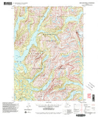
1994 Map of Port Alexander C-3
USGS Topo · Published 1998About this map
Baranof Island is defined here by its jagged fjords and high alpine peaks within the South Baranof Wilderness. The terrain is characterized by deep glacial carvings like Great Arm and Gut Bay, which reach far into the interior from the coastal waters of Whale Bay. High-altitude water bodies such as Plotnikof Lake and Deer Lake are connected by a network of drainage systems, often flanked by prominent peaks like Mt Yanovski and Mt Hagemeister. Human presence is minimal and temporary, primarily represented by remote U.S. Forest Service outposts including the Avoss Lake Cabin (FS) and Davidof Lake Cabin (FS). The Davidof Trail provides one of the few established routes through this part of the Tongass National Forest, following the rugged shoreline of RezañOf Lake.
Find a feature on this map
40 named features on this map. Tap any name to fly to it.
Don’t see what you’re looking for? This feature index may not catch every label — zoom into the map to look around manually.
Map Details
Editions of this 1994 Port Alexander C-3 Map
2 editions found

Other maps of this area

1948 · Port Alexander B-2
USGS Topo · 1:63,360

1951 · Port Alexander C-4
USGS Topo · 1:63,360

1951 · Port Alexander D-4
USGS Topo · 1:63,360

1951 · Port Alexander C-2
USGS Topo · 1:63,360

1951 · Port Alexander B-3 and B-4
USGS Topo · 1:63,360

1951 · Port Alexander C-3
USGS Topo · 1:63,360

1951 · Port Alexander D-3
USGS Topo · 1:63,360

1951 · Port Alexander
USGS Topo · 1:250,000

1951 · Port Alexander D-2
USGS Topo · 1:63,360

1951 · Port Alexander B-2
USGS Topo · 1:63,360