
1941 Map of Port San Luis
USGS Topo · Published 1941About this map
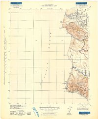
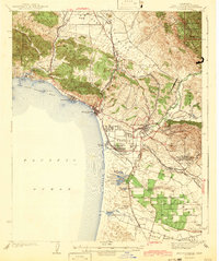
The coastal interface of the Diablo Range meets the Pacific Ocean in this survey based on data from 1939. The map centers on the steep, dramatic topography of the Central Coast, where peaks like Saddle Pk and Green Pk rise abruptly from the shoreline. The settlement at Port San Luis serves as the primary maritime anchor, sheltered by the prominent headland at Pt San Luis.
Find a feature on this map
16 named features on this map. Tap any name to fly to it.
Don’t see what you’re looking for? This feature index may not catch every label — zoom into the map to look around manually.
Map Details
Editions of this 1941 Port San Luis Map
This is the sole edition of this map. No revisions or reprints were ever made.
Other maps of this area

1897 · Port Harford
USGS Topo · 1:62,500

1897 · San Luis Obispo
USGS Topo · 1:62,500

1897 · Cayucos
USGS Topo · 1:62,500

1897 · Arroyo Grande
USGS Topo · 1:62,500

1900 · San Luis
USGS Topo · 1:125,000

1905 · Guadalupe
USGS Topo · 1:125,000

1937 · Cayucos
USGS Topo · 1:62,500
1942 · Guadalupe
USGS Topo · 1:125,000

1942 · San Luis Obispo
USGS Topo · 1:62,500
1942 · Arroyo Grande
USGS Topo · 1:62,500