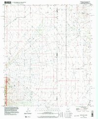
1996 Map of Portal NE
USGS Topo · Published 2003About this map
Coronado National Forest and the protected lands of the Chiricahua Wilderness dominate the southwestern corner of this landscape, where the terrain shifts toward the valley floor. The map records a sparsely developed borderland region defined by the state line between Arizona and New Mexico and the county boundary of Cochise and Hidalgo counties. Evidence of human infrastructure is concentrated along the Portal Road, including a Landing Strip and local GLO Station 5 markers.
Find a feature on this map
15 named features on this map. Tap any name to fly to it.
Don’t see what you’re looking for? This feature index may not catch every label — zoom into the map to look around manually.
Map Details
Editions of this 1996 Portal NE Map
This is the sole edition of this map. No revisions or reprints were ever made.
Other maps of this area

1917 · San Simon
USGS Topo · 1:125,000

1917 · Chiricahua
USGS Topo · 1:125,000

1918 · Pratt
USGS Topo · 1:62,500

1919 · Pratt
USGS Topo · 1:62,500

1919 · Chiricahua
USGS Topo · 1:125,000

1926 · Rodeo
USGS Topo · 1:62,500

1928 · Chenoweth
USGS Topo · 1:62,500

1950 · Vanar
USGS Topo · 1:62,500

1951 · Vanar
USGS Topo · 1:62,500

1954 · Silver City
USGS Topo · 1:250,000