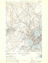
1948 Map of Portland West
USGS Topo · Published 1948About this map
Evergreen Cemetery and the sprawling rail yards of Deering Junction anchor this detailed post-war study of the city's western fringes. The landscape is defined by the winding Presumpscot River and the tidal reaches of Back Cove, where a complex network of iron connects the Maine Central RR, Grand Trunk RR, and Boston and Maine RR. This infrastructure supported the industrial heart of Westbrook and its Cumberland Mills, as well as the coastal commerce near Ligonia.
Find a feature on this map
93 named features on this map. Tap any name to fly to it.
Don’t see what you’re looking for? This feature index may not catch every label — zoom into the map to look around manually.
Map Details
Editions of this 1948 Portland West Map
This is the sole edition of this map. No revisions or reprints were ever made.
Other maps of this area

1891 · Portland
USGS Topo · 1:62,500

1892 · Freeport
USGS Topo · 1:62,500

1893 · Portland
USGS Topo · 1:62,500

1893 · Casco Bay
USGS Topo · 1:62,500

1894 · Gray
USGS Topo · 1:62,500

1898 · Gray
USGS Topo · 1:62,500

1914 · Portland
USGS Topo · 1:48,000

1914 · Casco Bay
USGS Topo · 1:48,000

1916 · Portland
USGS Topo · 1:62,500

1916 · Casco Bay
USGS Topo · 1:62,500