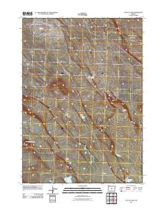
2011 Map of Potato Lake
USGS Topo · Published 2011About this map
Potato Lake sits at the heart of this high desert terrain in Deschutes County, surrounded by a series of shallow basins and ephemeral water bodies. The landscape is defined by its subtle relief, including the prominent Parmele Ridge and the volcanic profile of Studhorse Butte. Extensive open stretches like Canary Flat and Ant Flat dominate the area, revealing a pattern of natural drainages that feed into small, dispersed catchments such as Brooks Lake, Jones Lake, and Browns Lake. The absence of dense settlement highlights the arid character of the region during this period, with only a light network of unimproved roads connecting these named landmarks across the sagebrush-dotted flats. To the south, Hassler Lake provides another focal point in this sparsely populated pocket of Oregon.
Find a feature on this map
9 named features on this map. Tap any name to fly to it.
Don’t see what you’re looking for? This feature index may not catch every label — zoom into the map to look around manually.
Map Details
Editions of this 2011 Potato Lake Map
This is the sole edition of this map. No revisions or reprints were ever made.
Other maps of this area

1955 · Crescent
USGS Topo · 1:250,000

1957 · Crescent
USGS Topo · 1:250,000

1958 · Crescent
USGS Topo · 1:250,000

1970 · Crescent
USGS Topo · 1:250,000
1981 · Tired Horse Butte
USGS Topo · 1:24,000

1981 · Moonlight Butte
USGS Topo · 1:24,000

1981 · Chicago Valley
USGS Topo · 1:24,000

1983 · Potato Lake
USGS Topo · 1:24,000

1983 · Benjamin Lake
USGS Topo · 1:24,000

1983 · West of Hampton
USGS Topo · 1:24,000