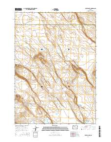
2014 Map of Potato Lake
USGS Topo · Published 2014About this map
Potato Lake sits at the heart of this high desert terrain, marking a landscape characterized by seasonal basins and volcanic rises. The boundary between Deschutes Co and Lake Co bisects the northern section, where the Central Oregon Hwy and Us-20 provide the primary corridor through the region. This 2014 survey illustrates a network of flats and ridges, including the prominent Parmele Ridge and the western landmark of Studhorse Butte.
Find a feature on this map
21 named features on this map. Tap any name to fly to it.
Don’t see what you’re looking for? This feature index may not catch every label — zoom into the map to look around manually.
Map Details
Editions of this 2014 Potato Lake Map
This is the sole edition of this map. No revisions or reprints were ever made.
Other maps of this area

1955 · Crescent
USGS Topo · 1:250,000

1957 · Crescent
USGS Topo · 1:250,000

1958 · Crescent
USGS Topo · 1:250,000

1970 · Crescent
USGS Topo · 1:250,000
1981 · Tired Horse Butte
USGS Topo · 1:24,000

1981 · Moonlight Butte
USGS Topo · 1:24,000

1981 · Chicago Valley
USGS Topo · 1:24,000

1983 · Potato Lake
USGS Topo · 1:24,000

1983 · Benjamin Lake
USGS Topo · 1:24,000

1983 · West of Hampton
USGS Topo · 1:24,000