1912 Map of Pounding Mill
USGS Topo · Published 1912About this map
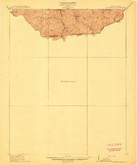
Big Creek defines the rugged terrain of this preliminary survey, capturing the borderlands between West Virginia and Virginia during the 1909-1910 field seasons. The map illustrates a landscape primarily shaped by its drainage network, with the isolated settlement of Horsepen situated near the headwaters of Horsepen Creek and Low Creek. To the west, Bearwallow Knob stands as a prominent landmark over the dissected ridges and deep valleys.
Find a feature on this map
14 named features on this map. Tap any name to fly to it.
Don’t see what you’re looking for? This feature index may not catch every label — zoom into the map to look around manually.
Map Details
Editions of this 1912 Pounding Mill Map
This is the sole edition of this map. No revisions or reprints were ever made.
Other maps of this area

1887 · Pocahontas
USGS Topo · 1:125,000

1889 · Wytheville
USGS Topo · 1:125,000

1891 · Tazewell
USGS Topo · 1:125,000

1891 · Pocahontas
USGS Topo · 1:125,000

1891 · Abingdon
USGS Topo · 1:125,000

1892 · Wytheville
USGS Topo · 1:125,000

1894 · Pocahontas
USGS Topo · 1:125,000

1894 · Abingdon
USGS Topo · 1:125,000

1895 · Tazewell
USGS Topo · 1:125,000

1895 · Pocahontas
USGS Topo · 1:125,000