1916 Map of Pounding Mill
USGS Topo · Published 1916About this map
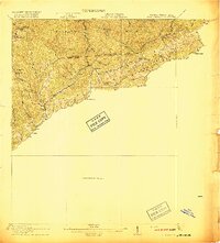
Big Creek Ridge and Big Stone Ridge dominate this 1916 survey of the borderlands between MC Dowell Co, West Virginia, and Tazewell Co, Virginia. The settlement pattern follows the narrow valley floors and watercourses, with small hubs like Canebrake and Sayersville tucked between the steep ridges. The Norfolk and Western RR cuts through the southwestern corner, following the path of Indian Creek and connecting communities such as Bandy, Harman, and Vandyke. Local education is anchored by several rural institutions, including Greasy Creek School and Rivermont School, marking the social centers for mountain families in the early twentieth century. The map illustrates a landscape of complex drainage systems, where the Laurel Fork and Dry Fork carve deep paths through the high terrain, defining the boundaries of remote settlements like Shraders and Adria.
Find a feature on this map
40 named features on this map. Tap any name to fly to it.
Don’t see what you’re looking for? This feature index may not catch every label — zoom into the map to look around manually.
Map Details
Editions of this 1916 Pounding Mill Map
This is the sole edition of this map. No revisions or reprints were ever made.
Other maps of this area

1887 · Pocahontas
USGS Topo · 1:125,000

1889 · Wytheville
USGS Topo · 1:125,000

1891 · Tazewell
USGS Topo · 1:125,000

1891 · Pocahontas
USGS Topo · 1:125,000

1891 · Abingdon
USGS Topo · 1:125,000

1892 · Wytheville
USGS Topo · 1:125,000

1894 · Pocahontas
USGS Topo · 1:125,000

1894 · Abingdon
USGS Topo · 1:125,000

1895 · Tazewell
USGS Topo · 1:125,000

1895 · Pocahontas
USGS Topo · 1:125,000