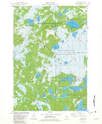
1981 Map of Powell
USGS Topo · Published 1982About this map
The Chicago and North Western rail line cuts a diagonal path through this lake-heavy stretch of Iron and Vilas counties, connecting small outposts like Powell and Powell No 2. The landscape is defined by its complex hydrology, featuring a dense cluster of water bodies including Dead Pike Lake, Sandy Beach Lake, and Pokegama Lake. Much of the territory is dedicated to conservation and indigenous land, split between the Northern Highland-American Legion State Forest and the Lac Du Flambeau Indian Reservation. In the central portion of the map, the expansive Powell Marsh State Public Hunting Grounds covers a significant area of wetlands. The presence of several Gravel Pits and the Manitowish Waters Airport indicates the intersection of resource extraction and local aviation infrastructure in this Northwoods region during the early 1980s.
Find a feature on this map
44 named features on this map. Tap any name to fly to it.
Don’t see what you’re looking for? This feature index may not catch every label — zoom into the map to look around manually.
Map Details
Editions of this 1981 Powell Map
This is the sole edition of this map. No revisions or reprints were ever made.
Other maps of this area

1938 · Lac Du Flambeau
USGS Topo · 1:48,000

1939 · Lac Du Flambeau
USGS Topo · 1:48,000

1939 · Winchester
USGS Topo · 1:48,000

1940 · Mercer
USGS Topo · 1:48,000

1941 · Pike Lake
USGS Topo · 1:48,000

1942 · Pike Lake
USGS Topo · 1:48,000

1945 · Mercer
USGS Topo · 1:48,000

1946 · Winchester
USGS Topo · 1:48,000

1946 · Lac Du Flambeau
USGS Topo · 1:48,000

1947 · Mercer
USGS Topo · 1:48,000