
1987 Map of Powell Mountain NE
USGS Topo · Published 1987About this map
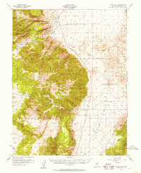
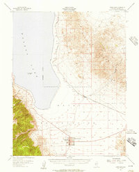
The Hawthorne Army Ammunition Plant dominates the transition between high desert peaks and the expansive Walker Lake Valley in this late twentieth-century survey. This region of Mineral County is defined by the steep elevation changes from the Wassuk Range in the west to the Garfield Hills in the east. Of particular interest to local historians is the location of Oro City (Site), a former settlement now marked only as a site, and numerous mining signatures scattered across the terrain. Remnants of the area's prospecting history are visible through several prospects and a documented Mine Shaft located south of the ammunition plant. The map traces the winding paths of Pamlico Canyon and Bromide Canyon, highlighting the complex drainage patterns that lead toward the valley floor, while Cottonwood Creek provides a rare watercourse through the arid landscape.
Find a feature on this map
13 named features on this map. Tap any name to fly to it.
Don’t see what you’re looking for? This feature index may not catch every label — zoom into the map to look around manually.
Map Details
Editions of this 1987 Powell Mountain NE Map
This is the sole edition of this map. No revisions or reprints were ever made.
Other maps of this area

1909 · Hawthorne
USGS Topo · 1:250,000

1911 · Hawthorne
USGS Topo · 1:250,000

1915 · Hawthorne
USGS Topo · 1:250,000

1948 · Walker Lake
USGS Topo · 1:250,000
1955 · Powell Mtn
USGS Topo · 1:62,500
1955 · Hawthorne
USGS Topo · 1:62,500

1957 · Walker Lake
USGS Topo · 1:250,000

1962 · Walker Lake
USGS Topo · 1:250,000

1964 · Walker Lake
USGS Topo · 1:250,000
1967 · Pamlico
USGS Topo · 1:24,000