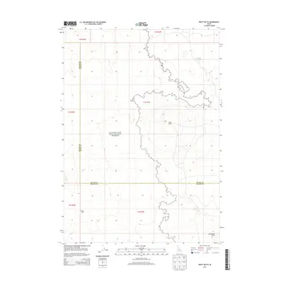
2013 Map of Pratt Butte
USGS Topo · Published 2013About this map
Craters Of The Moon National Preserve dominates this high-desert landscape in south-central Idaho, where the volcanic geology is mapped across the Blaine and Butte county lines. The survey highlights a desolate but geologically significant region defined by the Great Rift, a massive volcanic fissure system. Topographic detail illustrates the distinct elevation of Pratt Butte and the isolated Rattlesnake Butte to the southeast. Human impact is sparse, indicated primarily by the presence of Heifer Reservoir and the established boundaries of the national preserve, providing a specialized view of this lava-formed terrain as it appeared in the early 21st century.
Find a feature on this map
13 named features on this map. Tap any name to fly to it.
Don’t see what you’re looking for? This feature index may not catch every label — zoom into the map to look around manually.
Map Details
Editions of this 2013 Pratt Butte Map
This is the sole edition of this map. No revisions or reprints were ever made.
Other maps of this area

1955 · Idaho Falls
USGS Topo · 1:250,000

1958 · Idaho Falls
USGS Topo · 1:250,000

1972 · Quaking Aspen Butte
USGS Topo · 1:24,000

1972 · Antelope Lake
USGS Topo · 1:24,000

1972 · Pratt Butte
USGS Topo · 1:24,000

1972 · Bear Park East
USGS Topo · 1:24,000

1972 · Bear Park West
USGS Topo · 1:24,000

1972 · Fingers Butte
USGS Topo · 1:24,000

1972 · Serviceberry Butte
USGS Topo · 1:24,000
1973 · Fissure Butte
USGS Topo · 1:24,000